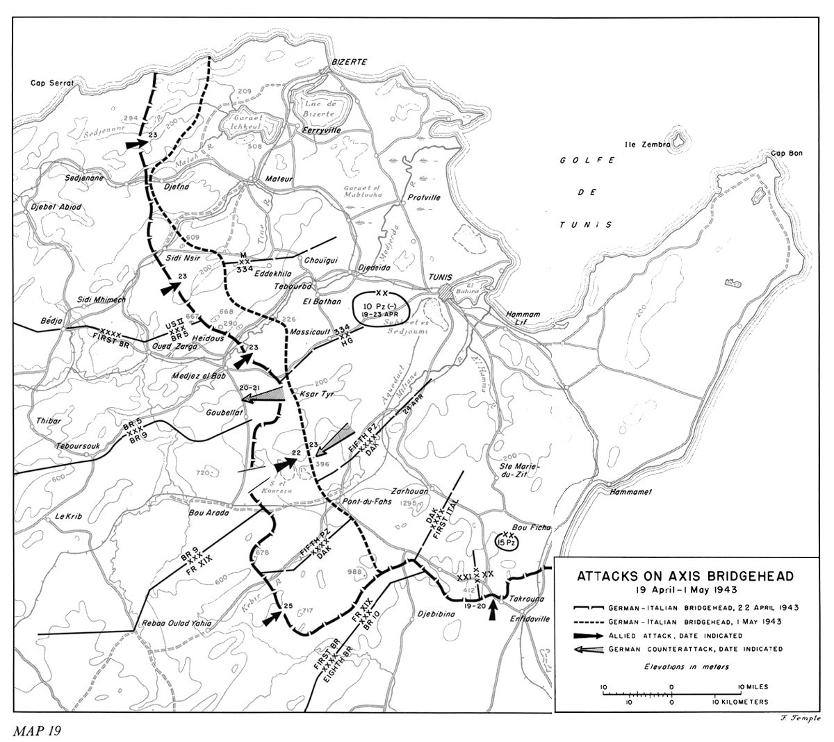
The Terrain of the Enemy's Bridgehead
The campaign in Tunisia moved during April to the opening of its final phase. At the beginning of the month, the enemy's defense in southern Tunisia had collapsed. During the second week, he had gathered his forces in a compact sector in northeastern Tunisia behind a great arc extending from a point on the north coast east of Cap Serrat to Enfidaville and the Gulf of Hammamet on the southeast. (Map 19) His forward positions extended over mountains and valleys, plains, and marshlands, at a distance of thirty or more miles from the ports of Bizerte and Tunis, the main Allied objectives. While the enemy was strengthening his line, the Allies also regrouped and reorganized, with a view to pushing the line back on the flanks and piercing it in the center, south of the Medjerda river. They were ready, by the third week of April, to launch the culminating offensive. The incentive to complete the campaign in northwestern Africa at the earliest possible moment was very great. The seizure of Sicily, which was next on the Allied schedule, had to be accomplished early in the summer if it were to leave time for an important sequel in 1943.
The enemy's bridgehead contained five major regions to which the Allies had to adjust their plans and operations: (1) that north of the Medjerda river; (2) that between the Medjerda and the Miliane river with its tributary, the Kebir river; (3) that from the Miliane and Kebir rivers to the foothills on the western edge of the coastal plain; (4) the coastal plain and the flats at the base of the Cap Bon peninsula; and (5) the Cap Bon peninsula.
The first of the subdivisions is an almost rectangular area trending northeast-southwest, with Bizerte in the northeastern corner and Medjez el Bab at the southwest. Its western half is covered by hills and low, unforested mountains except close to the seacoast between Cap Serrat on the west and Bizerte on the east. The hills defy all efforts to organize them into recognizable patterns but, in general, consist of a series of widely varying complexes in which a higher crest and neighboring hills form interlocking groups. Foremost among these complexes is the one including Djebel Tahent (Hill 609) near Sidi Nsir, from whose summit it is possible to see Mateur. Fingers of high ground project from the mountain area northeastward across the coastal plain, thus enclosing a section adjacent to Bizerte and separating it from a second and narrow area north of the Medjerda between Tebourba and the ocean. Two great shallow lakes, the Garaet Ichkeul and the Lac de Bizerte, southwest and south of Bizerte, confine all overland approach to the city to narrow

Map 19
Attacks on Axis Bridgehead
19 Aprilń1 May 1943
belts between the shores and the hills. The Tine river runs northeast and north from sources south of Hill 609 to the plain near Mateur.
Access from this northern portion of the enemy's bridgehead to that south of the Medjerda river is easiest via bridges at Medjez el Bab, El Bathan (near Tebourba), Djedeïda, and Protville nearest the river's mouth. This second subdivision is narrower, and more nearly trapezoidal, with a western side running almost due south from Medjez el Bab to Djebel Mansour (678) and the Kebir river, and with the Medjerda on the northwest and the Miliane at the southeast converging somewhat as they approach the ocean. In this area the enemy had pushed an even shorter distance into the hills from the inland margin of the coastal plain. Of the two fingerlike extensions of lower hills projecting northeastward here, the one nearer the Medjerda had been the scene of the battles of Combat Command B, U.S. 1st Armored Division, in defense of Medjez el Bab in early December. The other is a wedge narrowing from the Sebkret el Kourzia at its southwestern base to a point southeast of Massicault. Between these two fingers is the Goubellat plain, from which a force approaching Tunis could emerge onto the coastal plain by passing through an opening northwest of Ksar Tyr. The principal road from the west to Tunis crosses the Medjerda river at Medjez el Bab to enter this second subdivision of the bridgehead, continues generally east through a gap in the northern series of hills, and swings northeastward through Massicault to Tunis. Another road passes through Pont-du-Fahs, on the southern edge of the area, and along the Miliane river to Tunis. From the Bou Arada valley west of Pont-du-Fahs, an easy approach to Tunis requires a route either
through Pont-du-Fahs or over the Goubellat plain, routes that in each case arrive at the broad coastal plain from a slightly higher area after passing through relatively narrow outlets. Tunis itself is in this region, and is ringed closely on the north and west, and at a greater distance on the south and southeast, by a series of low hills. The city lies between the western edge of El Bahira lake and the northeastern rim of the still shallower Sebkret es Sedjoumi.
The relatively long and narrow third subdivision of the enemy's bridgehead, that between the Miliane river and the coastal plain on the Gulf of Hammamet, includes a segment of the higher mountains which stretch across Tunisia northeasterly as far as Cap Bon. Here the enemy's forward line in April continued southeast from Djebel Mansour, crossed the Kebir river, and turned northeastward, after circling Djebel Chirich (717), into the hills which formed the enemy's Enfidaville position. The mountains in this subdivision are divided into two major sections by an east-west valley at the northern edge of Djebel Zarhouan (1295), along which runs a road connecting the Miliane valley road net with the coastal highway at Bou Ficha. The mountainous section north of this transverse valley is further divided into an eastern and a western segment by a valley and north-south road between Tunis and Ste. Marie-du-Zit. Here was an area which offered opportunity for a long-drawn out defense and which contained valuable routes that could be used to shift strength quickly to effective points for counterattack.
The coastal plain at the southeastern limit of the enemy's forward line narrows to a ribbon of flatland adjacent to the Gulf of Hammamet as the foothills on the west jut eastward near Djebibina and Takrouna toward the shore. Enfidaville is a road center at the southern end of this ribbon. Although the coastal plain throws out an arm toward Zarhouan west of Bou Ficha, it remains narrowly confined as it extends northeastward. Near Hammamet it merges with the triangular-shaped flats at the base of the Cap Bon peninsula, and on the other side of these flats, narrows to the very limited shelf near Hammam Lif, where the distance between steep heights and the surf of the Golfe de Tunis is only a few hundred yards. The coastal plain is thus readily defensible against an armored force by troops possessing the heights and equipped with appropriate weapons.
Cap Bon is at the northeastern tip of a peninsula approximately fifty miles long and from fifteen to twenty-five miles wide. A ridge extending from Hammamet to Cap Bon falls away in a great series of shoulders and gullies to coastal lowlands and, except near the base, confines the roads to a loop around the outer edge. The peninsula has no sheltered ports of any consequence, but its long coast line has many stretches of beach and several small ports which could be used for the reinforcement, supply, or the evacuation of troops by small craft. The Allies were alert in April to the possibility that the Cap Bon peninsula might be used as the site of a last-ditch, Bataan-like defense which could drag out the operations in Tunisia and disrupt preparations to seize Sicily.
The Allied Plan of Attack
Allied plans for the attack were under consideration at the highest levels of command even before operations in southern and south central Tunisia were at full scale. General Alexander's thorniest problems were to determine the axis of main attack
and the mission for U.S. II Corps. He had retained General Anderson in command of British First Army, to whose operations he himself gave close personal attention, and he decided to follow General Eisenhower's suggestion that the chief effort be made toward the east through First Army's sector. Allied concentration and preparation there could be completed sooner, and subsequent maintenance would be easier. First Army, which may have felt that its hard fighting had not been properly recognized by the general public, would thus have its chance to gain renown. But what would be done with II Corps? "I desire that you make a real effort to use the II U.S. Corps right up to the bitter end of the campaign, even if maintenance reasons compel it to be stripped down eventually to a total of two divisions and supporting Corps troops," wrote the Commander in Chief, Allied Force, at the same time that he suggested a major role for First Army.1 It should be given a mission, he prescribed, which would keep it committed aggressively. If any Allied sector was to be narrowed or pinched out by the northward progress of Eighth Army and the eastward drive by First Army, the best interests of the Allied military effort required that the sector not be that of the U.S. II Corps. That force must be used fully until the enemy capitulated, both in order to furnish experience which would be devoted subsequently to training the only great body of Allied reserves--that being organized in the U.S.--and to serve the needs of American morale.2
In conformity with these suggestions, General Alexander's staff drafted plans by 8 April which included provision for a II Corps zone at the northern flank of the Allied front. The Combined Chiefs of Staff approved the project on 9 April, and on the next day the plans were back in General Alexander's hands with instructions to execute them. He then issued preliminary instructions to the commanders of British First Army and Eighth Army. He directed Anderson to prepare to make the main attack about 22 April. He instructed Montgomery, who had requested on 11 April the immediate transfer of the British 6th Armoured Division to his operational command, that the Eighth Army was to conduct a subsidiary operation rather than to attempt a sudden piercing of the Enfidaville position, and that Montgomery was to release an armored division and an armored car brigade to strengthen First Army's attack. On 12 April, discussing with General Alexander the role of II Corps, General Patton objected to a proposal that II Corps, which had operated since 8 March directly under 18 Army Group, should be subordinated once more to British First Army. On 14 April, General Eisenhower flew to Haïdra to confer with Generals Alexander, Anderson, Patton, and Bradley on the plans, and in particular on the arrangements respecting II Corps. British 9 Corps' attribution of the blame for failure at Fondouk el Aouareb to inferior performance by the U.S. 34th Infantry Division, the low regard in which General Alexander and some of his staff held the U.S. 1st Armored Division, and the reluctance of Alexander's logistical advisers to see the Allied line of supply in the north burdened by the requirements of a full four-division American corps, were all
factors which had led Alexander to reconsider the subject of fully using American troops under American command during the next phase of the Tunisian campaign. At the insistence of the Americans, he assented to these arrangements. On 16 April, 18 Army Group issued the final plan. The Allied operations were intended to tighten the cordon around the enemy, to drive a wedge dividing the portion of his bridgehead adjacent to Tunis from that near Bizerte, to seal off the Cap Bon peninsula, and to overwhelm first the defenders of Tunis and next the defenders of Bizerte. A program to strangle the Axis line of supply was ready as well as another operation to forestall the evacuation of substantial forces to Sicily or Italy.3
Alexander directed Eighth Army to exert continuous pressure on its front, and to advance on the axis EnfidavilleńHammametńTunis in order to bar access to the Cap Bon peninsula. First Army was to capture Tunis, then aid U.S. II Corps in capturing Bizerte, and be prepared to aid the Eighth Army if the enemy should succeed in withdrawing onto the Cap Bon peninsula. British Eighth Army prepared to attack the Enfidaville line on the night of 19ń20 April, an operation timed to draw enemy reinforcements to that portion of the front, where they were to be held by continued pressure.
West of the Eighth Army, at the southwestern corner of the enemy's bridgehead, British First Army had directed the French XIX Corps to attack on the axis Rebaa Oulad YahiańPont-du-Fahs in order to reopen the road and make possible progress toward Zarhouan. This mission involved the clearing of Djebel Chirich and Djebel Fkirine (988) on the south side of the road and Djebel Mansour on the north side of the road, an effort which was to be started only after the attack on each flank had reached a suitable stage.
British 9 Corps was to mount its attack from an area southwest of Bou Arada, with its objective the high ground adjacent to the Sebkret el Kourzia, northwest of Pont-du-Fahs. From this point 9 Corps could threaten the main highway between Pont-du-Fahs and Tunis, and could also assist British 5 Corps.
British 5 Corps was to make the main effort. It was first to regain Longstop Hill and "Peter's Corner" (southeast of Medjez el Bab on the Medjez el BabńMassicault highway; see Map VIII) and next to gain the high ground between El Bathan and Massicault. The attacks by British 9 and 5 Corps were both to be launched on 22 April, the former at daybreak and the latter shortly after dark.
On the northern flank, the U.S. II Corps was expected to advance eastward from Bédja to Chouïgui, and at the same time, nearer the northern coast, to expel the enemy from Bald and Green Hills (known as the Djefna position) and gain control of
high ground dominating a road junction northwest of Garaet Ichkeul.4
An elaborate Allied air forces' program to choke off the air supply line from Italy became effective during the planning. Known as Operation FLAX and postponed for various reasons since February, it began as the enemy came under attack in the Chott Position on 5 April. Two Allied flights struck formations of enemy transports en route to Tunisia over the Sicilian straits early that morning, while a little later B-17's hit the Bizerte and Tunis airdromes in an effort to catch those transports which got through. Other bombers went to Sicily to destroy any transport aircraft which might be staging there in a second flight en route from Italy to Tunisia. Fighter sweeps contributed to the whole operation, which may have destroyed as many as 161 aircraft on the ground and 40 in the air.5
The Western Desert Air Force soon afterward occupied bases from which its fighters could operate over the Golfe de Tunis and join in intercepting enemy air transports. On 18 April, five squadrons intercepted a mixed and scattered formation of Junkers 52's and Messerschmitt 323's at a very low altitude and already in sight of the coast, and striking from the right rear, destroyed thirty-eight of them.6 Next day, a smaller success was achieved, and as the ground offensive began on 22 April, thirty-nine more enemy transports were intercepted and destroyed. Some burst into flames as if carrying cargoes of gasoline. Thereafter, the enemy limited his air supply route to night operations and to individual rather than formation flights.7 Allied night fighters interfered with that method, too.
The Enemy's Plans and Regrouping
However desperate the Axis position might seem after the loss of the Chott Position, Hitler did not budge from his determination to hold on. On 8 April he had to confront Mussolini, now deeply concerned about the expected Allied invasion of Italy, when the Duce arrived at Schloss Klessheim, with an Italian delegation, for the annual conference of the Axis partners.
As in previous discussions with Goering and Ciano, Mussolini pleaded that Germany come to terms with the USSR and turn all its energies against the Allies in the Mediterranean. His plan for preventing
the Allied invasion of the European mainland was to hold in Tunisia and fall on the Allied forces from the rear by attacking through Spain and Spanish Morocco and seizing the Balearic Islands.
Hitler was interested only in holding in Tunisia. The conflict with the Soviets admitted of no compromise, and even if forces were available a move through Spain or a seizure of the Balearics would arouse the Spaniards to stubborn, unending resistance. The Axis could hold Tunisia indefinitely, and as long as the Allies were kept fighting there, they could not undertake other large-scale operations; Italy, Sicily, and the French Mediterranean coast were therefore in no immediate danger. In any case, the best Axis troops were in Tunisia and their evacuation was impossible. Mussolini had to be satisfied with the old assurance that Italy and Germany would stand or fall together. Hitler even induced him, in exchange for renewed promises of reinforcements, to agree to having the Italian cruisers and destroyers still in action used to transport men and materials to Tunisia--an agreement from which Mussolini began to retreat as soon as he reached the soberer atmosphere of his own headquarters in Rome.8
The Duce, conferring with Kesselring on 12 April after he got back from Germany, reiterated that the Axis had to get sufficient men, ammunition, replacement parts, and fuel to Tunisia without delay.
We have to hold [he said] . . . . We can hold out two months. We must create a system of defense with one line behind another in depth . . . . I am convinced that the Americans will do nothing [elsewhere] before having settled the Tunisian problem. Only then will they eventually attack Sardinia, Sicily, Crete, etc. If we succeed in shifting the start of these attacks, we shall see that in the short time remaining before winter, they will do nothing . . . . Everything can happen if we persist, and therefore we shall hold.9
Army Group Africa prepared to hold out in conformity with the decision of the two Axis political leaders. All men in Tunisia were to be used either to fight or to construct field fortifications. Troops of the rear were placed under the general control of Headquarters, Fifth Panzer Army, and were to be assembled in units of 500 under command of energetic officers for commitment as needed. Motor vehicles were organized in transport columns of fifty-ton capacity and held at the disposal of the army group. The primitive Enfidaville line was to be developed in depth. Coastal defense as well as retention of interior sectors became the responsibility of the two Axis armies. After the front was firmly established, with German and Italian battalions interspersed, and with all Axis tanks and at least two armored divisions available for a mobile reserve, the armored forces were to be placed under the control of Headquarters, German Africa Corps. Italian tanks would pass to Division Centauro, which would in turn be attached to a German armored division.10
Kesselring reported to Mussolini on the situation in Tunisia on 17 April, directly after making his last personal visit there. The Axis line had been rendered satisfactory, he said, in all but two points: at Medjez el Bab and on the coastal plain near Enfidaville. Here General von Arnim was withdrawing the main line to stronger and more favorable positions and, while preparing a second line, was already planning a third. Axis reserves were being flown to Tunisia at a daily rate expected to average from 1,800 to 2,000 men, after a week in which air transports brought in 4,000, while destroyer-transports brought others at a slower rate. He would hold in Italy a pool of about 12,000 from which to draw. On 20 April, as a birthday gift to the Fuehrer, he planned to make an attack, despite some matériel shortages, especially in fuel. Allied aviation was ominously quiet but Allied airfields were being kept under close surveillance and were about to be subjected to Axis attacks. Although Allied tank strength was still greatest on the coastal plain in the southwest, Kesselring expected much of the British armor to be shifted to the north before the Allied attack began.11
The enemy's forward line was under steady and sometimes overwhelming Allied pressure as the main offensive was being prepared. At the northern end, the British 46th Division forced Division von Manteuffel to give ground so that when the U.S. 9th Infantry Division took over the British positions at 1800, 14 April, most of the area gained by Axis attacks since 26 February had already been recovered by the British. Just before the Allied attacks began on 19 April, that portion of the Axis front ran, therefore, from a cape north of Djebel Dardyss (294) through the Djefna position to the vicinity of Sidi Nsir. The 334th Division (Korpsgruppe Weber) had successfully withstood the attacks of the British 4th Division toward Sidi Nsir and the hills south of it, but after stubborn defense northwest and north of Medjez el Bab, was pushed back from the crest of Djebel Bech Chekaoui (667) and neighboring heights. From these bold ridges Allied observers could keep "Longstop Hill" (290) under surveillance and see over it to the Medjerda river plain beyond.
East of Medjez el Bab and south of the main highway to Tunis, the Hermann Goering Division (-) held a section of the front extending to Djebel Mansour, in contact there with the right flank of the German Africa Corps. After the withdrawal into the Enfidaville Position, this corps had assumed command of the zone between the Fifth Panzer and Italian First Armies with the Superga, 10th Panzer and 21st Panzer Divisions, and the remaining Italian troops of the XXX Corps and 50th Special Brigade. Starting on 21 April the armored and mobile elements of the Panzer divisions were gradually withdrawn from this sector which was mountainous. The 10th Panzer Division (-) was initially moved to the Medjerda plain west of Tunis to serve as mobile Fifth Panzer Army reserve against the expected Allied thrust against Tunis.12
The southeastern portion of the bridgehead was defended by Italian First Army, with XXI and XX Corps headquarters. The Spezia Division was farthest inland, then the 164th Light Africa Division, and on hills farther east, the Pistoia, Young Fascists, and Trieste Divisions. On the coastal plain was the 90th Light Africa Division, with the 15th Panzer Division under Army Group Africa's control in a second, supporting position southeast of Zarhouan. The remnants of the Luftwaffe Parachute Brigade, now commanded by a Major von der Heydte, the 19th Flak Division, and Division Centauro were used to strengthen this part of the bridgehead's defense. German elements of Italian First Army were controlled through General Bayerlein. A Bizerte Coast Defense Command under Gen. Kurt Bassenge of the 20th Flak Division furnished small units used in the northern sector but was principally concerned with operation of the coastal and antiaircraft guns used to defend that port and its neighboring airfield. The Tunis Coast Defense Command had similar duties.13
Allied Regrouping
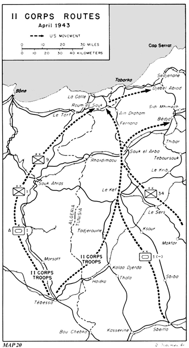
Allied regrouping along the new line involved the transfer of a considerable force from the British Eighth Army on the coastal plain near Kairouan to the zone of British 9 Corps east of Le Kef, and the shifting of over 90,000 men of the U.S. II Corps from south central Tunisia to a new zone northeast of Bédja. Since it had been in prospect for nearly a month the movement by U.S. 9th Infantry Division to the northern end of the line of commitment under British 5 Corps was accomplished as soon as the fighting near El Guettar had ceased. The division moved northward in eastern Algeria along the main road between Tébessa and Souk Ahras, and thence northeastward through the cork forest near Tabarka and the village of Djebel Abiod to the hills near Sedjenane. (Map 20) The 47th Infantry Regiment began relieving elements of the British 46th Division on the night of 12-13 April. The decision to install the whole U.S. II Corps in that part of the Allied front was reached later and less firmly, so that planning and preparations to move it were more hurried. To regulate the heavy transverse movement of II Corps across the very active east-west supply routes of First Army, and to shift British armored troops from the east coast through the II Corps area to that of British 9 Corps, required a high degree of co-ordination between staffs of II Corps and of First Army. Most of the mileage covered by II Corps units lay within British First Army's zone, where a new corps area was not established until after the bulk of the American troops had arrived, and where all troop movements were under First Army's control.
Actual arrangements were preceded by a road reconnaissance in which representatives of the G-3, provost marshal, and Engineer sections of II Corps joined officers of the Movement Controls Branch, British First Army. They selected a route along which, it was believed, control points could be established and traffic be regulated to meet an average rate of 100 vehicles per hour.
The most direct route from Tébessa to Roum es Souk (about fifteen miles southwest of Tabarka and in the cork forest)

Map 20
II Corps Routes
April 1943totaled about 140 miles. It ran through Haïdra to Tadjerouine to Le Kef, a road junction on an important British supply route from Souk Ahras eastward. North of Le Kef the second half of the route became twisting, narrow, and subject to poor visibility and to one-way traffic except at limited passing points. Bridges were narrow and grades often steep. At Souk el Arba, the route crossed the principal highway and railroad from Souk Ahras to Tunis, and continued through Fernana and Aïn Draham to the Roum es Souk area. The northbound traffic crossed the two major west-east highway and railroad routes, and made use of almost ten miles of one of these roads in approaching the road junction at Le Kef. The narrow road north of Le Kef was used alternately for traffic going in each direction. In order to make the fullest use of the time allowed for American northbound columns, the II Corps vehicles assembled near its southern terminus in numbers calculated to make fullest use of each allotted period, and to take advantage of any unscheduled additional opportunities.
Besides the 1st Infantry, 1st Armored, and 34th Infantry Divisions, the corps had to transfer its headquarters and approximately forty Ordnance, Medical, Quartermaster, Engineer, Chemical Warfare Service, and Signal units of varying size. The divisions were subdivided into combat teams, which along with the corps troops, were given priorities in a tentative schedule providing for 2,400 vehicles per day. Each day's contemplated movements were reported on the previous day through the British Movements Control liaison officer at Tébessa to Headquarters, First Army, which regulated traffic across its area to the vicinity of Roum es Souk. The II Corps assembled its units in the Tébessa area at those periods between 14 and 18 April which were best adapted to the whole volume of transportation within First Army's area, and fed them from these assembly points to the southern terminus of the main, one-way bottleneck. There the intermediate assembly served as a sort of reservoir, with earlier arrivals marching out as often and as long as the route farther north could be

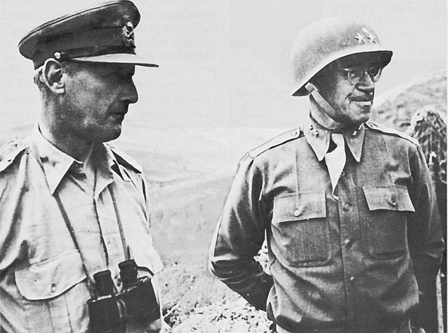
MAJ. GEN. OMAR N. BRADLEY (right) after he assumed command of U.S. II Corps and Lt. Gen. Kenneth A. N. Anderson, commander of the British First Army.held open, while others were arriving from the initial points of departure.14
The plan thus created was modified on army group instructions during 17 and 18 April, when all II Corps units were sent to Roum es Souk by the longer road which part of the 9th Infantry Division had used a week earlier, the one through Morsott, Souk Ahras, and Le Tarf, thus avoiding the congestion near Le Kef.15 The 1st Infantry Division moved northward over this route on 18 April. The U.S. 1st Armored Division, leaving its Combat Command A to move by way of Morsott, started north behind the British 1st Armoured Division and King's Dragoon Guards. The division assembled near Sbeïtla and moved up the road through Sbiba to Le Kef on 19 April. The British column which preceded them had covered the characteristically tawny paint on 4,000 British Eighth Army vehicles with the dark green of First Army, and left the coastal plain in a wide southerly loop through Faïd pass, Sbeïtla, and Ksour to Le Kef. The 105 tank transporters which
had been placed at the head of the long column were released temporarily to supplement those of the U.S. 2622d Tank Transporter Company in moving Combat Command B, U.S. 1st Armored Division's medium tanks through Le Kef to a staging point near Rhardimaou. Meanwhile lighter elements of the division passed through Souk el Arba to the cork forest near Roum es Souk.16
The 34th Infantry Division, in order to avoid conflict with the British 6th Armoured Division in joint use of the road between Pichon and Maktar, was brought northward in two major sections, via Le Sers and east of Le Kef to Souk el Arba and the cork forest, on the nights of 21ń22 and 23ń24 April.17
Transfer of the bulk of II Corps to the northern zone required good administrative co-ordination but was not otherwise extraordinarily difficult. The marches were much shorter than those which many of the units had made in coming east into Tunisia from Algeria, and they were not made under air attacks of such strength and persistence that all traffic had to be done at night and under blackout conditions. The problems were principally to make effective use of all available transportation facilities and to avoid congestion at critical points. A more threatening difficulty was the provision of sufficient supply and maintenance to the II Corps in the new zone. Simultaneously with the northward shift of troops, II Corps had to accumulate a six days' level of supply at accessible forward dumps and to arrange for systematic resupply in the amount of 800 tons daily. Stocks in central Tunisia were allowed to dwindle, and a substantial quantity of ammunition was trucked from there to the vicinity of Djebel Abiod to meet initial requirements. On 20 April, out of a total requirement of 3,780 tons of ammunition, all but 1,123 were on hand or en route and the supply system was in order. Bône was the site of the Eastern Base Section's main depot on which II Corps was expected to draw. Railheads at Bédja, Sidi Mhimech a few miles northeast of it, and Djebel Abiod were to become the main corps supply points. Eastern Base Section and the G-4 section of II Corps under Col. Robert W. Wilson, worked in close co-operation, the former taking over forward dumps as soon as the attack moved eastward a few miles. To have on hand the means to begin the attack during the night of 22-23 April, all available trucks were used around the clock, with alternating crews, and with headlights as needed.18
The burden on Allied supply lines from the western Mediterranean was increased by the quantities they provided for the British Eighth Army. Stocks of gasoline held at Gafsa and Bou Chebka totaled 3,700 tons. Lighters began unloading supplies for the Eighth Army at Gabès on 3 April and small vessels at Sfax on 14 April. But a railhead for the Eighth Army at Sbeïtla was also scheduled to receive 500 tons per day from the west. When large units were shifted from the Eighth to the First Army before and
during the last battles, they drew rations and ammunition from the railroad through Le Kef to Bou Arada, or from the highway between Le Kef and Teboursouk at Le Krib.19
On 15 April, command of II Corps passed quietly from Patton to his deputy commander of the past six weeks, General Bradley. Patton returned to the planning for American participation in the invasion of Sicily (Operation HUSKY) as had been contemplated when he took command of the II Corps on 6 March. Bradley's earlier active participation in direction of the II Corps minimized the consequences of the shift. On 16 April, his headquarters moved from Gafsa to a newly established site near Bédja. The relief of the British units by the Americans and all road movements remained under control of British 5 Corps until 1800, 19 April, when Headquarters, II Corps, officially assumed command of its new area, with a forward line running from the ocean east of Cap Serrat to Hill 667, five miles west of Heïdous.20
As the time for the attack drew near, the Allied forces moved into battle position. General Alexander's headquarters shifted on 20 April to a point about fifteen miles southwest of Le Kef. General Anderson was already established in a farm near the White Fathers' monastery on the heights of Thibar, fifteen miles along the road from Bédja south to Teboursouk, and on the south side of the Medjerda river. General Bradley's command post was organized on 15 April two miles northwest of Bédja in tents on a farm belonging to the mayor. The corps commanders of First Army explained their respective plans at a conference at Thibar on 18 April, and next morning General Bradley went over plans with his staff and division commanders.21
Table of Contents ** Previous Chapter (30) * Next Chapter (32)
Footnotes
1. Ltr, CinC, AF to CG 18 A Gp, 23 Mar 43. Copy in OPD Exec 8, Bk. 8, Tab 53.
2. Queries, CinC AF to CG 18 A Gp, in FRCOS to 18 A Gp, No. 1044, 2 Apr 43; Ltr, CinC AF to CofS, 29 Mar 43. Copies in OPD Exec 8, Bk. 8, Tab 53.
3. (1) 18 A Gp Opn Instruc 12, 16 Apr 43. AFHQ Micro Job 10A, Reel 6C. (2) Msg 2921, AFHQ G-3 to 18 A Gp, 10 Apr 43. (3) Patton Diary, 9, 11, and 12 Apr 43. (4) Alexander, "The African Campaign," p. 878. (5) Leahy, I Was There, p. 147, cites approving action by the Joint Chiefs of Staff and the British Chiefs of Staff on 9 April 1943. (6) Bradley, A Soldier's Story, pp. 72-73. (7) Msg, AGWAR to FREEDOM, 9 Apr 43. CM-OUT 5656.
The II Corps was to remain under 18 Army Group but with First Army authorized to issue directly the orders necessary for co-ordinating the corps' operations with those of First Army. In effect, First Army commanded II Corps in the name of the army group, but the Commanding General, II Corps, was free to bring any matter of serious disagreement to Alexander for decision.
4. First Army Opn Instruc 37, 19 Apr 43, copy in II Corps AAR, 15 May 43. The order of battle for British First Army and U.S. II Corps was given as follows:
U.S. II Corps 1st Armored Division (less 1st Armored Regiment)
1st Infantry Division
9th Infantry Division
34th Infantry Division
Corps Franc d'Afrique (three battalions)British 5 Corps 1st Infantry Division
4th Infantry Division
78th Infantry Division
25th Tank Brigade (less 51st Royal Tank Regiment)British 9 Corps 1st Armoured Division
6th Armoured Division
46th Infantry Division
51st Royal Tank RegimentFrench XIX Corps Moroccan Division
Algiers Division
Oran Division
Tank Battalion (Valentines and Somuas)
18th King's Dragoon Guards5. AAF, History of the Twelfth Air Force, Operation FLAX, pp. 1-6. AAF Archives.
6. MS # D-071 (Buchholz). Estimates then were seventy-four destroyed and twenty-nine damaged.
7. (1) Ibid. (2) Info supplied by Air Ministry, London.
8. (1) Ltr, Mussolini to Hitler, 26 Mar 43. (2) Tels, Mackensen to Ribbentrop, 31 Mar, 1 Apr 43. (3) Aufzeichnung ueber die Unterredung: zwischen dem RAM und dem Staatssekretaer Bastiniani in Anwesenheit der Botschafter von Mackensen and Alfieri im Schloss Klessheim am 8. April 1943, nachmittags und am 9. April 1943 vormittags; zwischen dem RAM und Staatssekretaer Bastiniani im Schloss Klessheim am 9. April nachmittags; zwischen dem Fuehrer and Marschall Antonescu in Klessheim am 12. April um 5 Uhr nachmittags. All in German Foreign Office Files, Historical Division, Dept of State. (4) OKW/WFSt, KTB, 1.VII.ń30.IX.43, 15 Jul 43.
9. Conf, Duce with Kesselring, 12 Apr 43, in Italian Collection, Item 26.
10. Operation Order, Army Group Africa, Nr. 2006/43, dated 11 Apr 43, in Fifth Panzer Army, KTB mit Anlagan vom 11.IVń21.43.
11. Conf, Duce, Kesselring, and Ambrosio, 17, 20 Apr 43, in Italian Collection, Item 26.
12. (1) Maps, Lage Nordafrika (1:500,000) GenStdH/Op Abt IIIb, Pruef Nr. 19457 and 19629, 18, 19 Apr 43. (2) Daily Rpts, Army Group Africa to OKH/GenStdH/Op Abt, 19-21 Apr 43, in OKH/GenStdH/Op Abt, Tagesmeldungen H. Gr. Afrika vom 1.IV.ń12.V.43 (cited hereafter as Army Group Africa, Sitreps). (3) Contemporary estimate at AFHQ of these units was as follows: Division von Manteuffel, 4,500; 334th Division, 9,450; Hermann Goering Division, 10,000; 10th Panzer Division, 10,000, Units of the 999th Division, part of which was used to reinforce Division von Manteuffel, 5,800.
13. Strength of the German units was estimated, 18 April, to be as follows: 15th and 21st Panzer Divisions, 5,600 each; 90th Light Africa Division, 6,000; 164th Light Africa Division, 3,000; 19th and 20th Flak Divisions, 13,000; Marsch Battalions, 14,930.
14. (1) Info supplied by Col Robert A. Hewitt, former G-3 II Corps. OCMH. (2) II Corps G-3 and G-4 Jnls, 12-23 Apr 43.
15. (1) Msg 18 A Gp to First Army and II Corps, 2145, 16 Apr 43, Entry 65, in II Corps G-3 Jnl. (2) 1st Div AAR.
16. 1st Armd Div FO 21, 0900, 19 Feb 43.
17. 34th Div FO 34, 1700, 20 Apr 43, and Annex A (March table).
18. (1) Memo, Ordnance Officer II Corps to CO EBS, 20 Apr 43, sub: Ammo sit at La Calle. (2) Both ammunition and gasoline consumption (68,633 gallons daily) ran under estimates, although some kinds of ammunition became scarce. Memo, G-4 II Corps for CofS II Corps, 30 Apr 43, in II Corps G-4 Jnl. (3) Msg EC-1011, EBS to FREEDOM, 21 Apr 43. AFHQ CofS Cable Log, 123. (4) See Lt. Col. J. W. Smith, "Logistics As Seen From a Corps Level," Military Review, XXVI, No. 7 (October, 1946), pp. 58-62.
19. (1) Info supplied by Cabinet Office, London. (2) Msgs Q 419, Q 420, and Q (M) 130, 18 A Gp to FREEDOM, 16 May 43. AFHQ CofS Cable Log.
20. (1) II Corps AAR, 15 May 43. (2) Msg, 18 A Gp to FREEDOM, 19 Apr 43. AFHQ CofS Cable Log. (3) Col. William B. Kean relieved General Hugh Gaffey as chief of staff, and Col. Robert A. Hewitt resumed his functions as G-3 as Colonel Lambert took command of Combat Command A, 1st Armored Division, in place of General McQuillin.
21. (1) II Corps G-3 Jnl, 19-20 Apr 43. (2) Bradley, A Soldier's Story, p. 75.