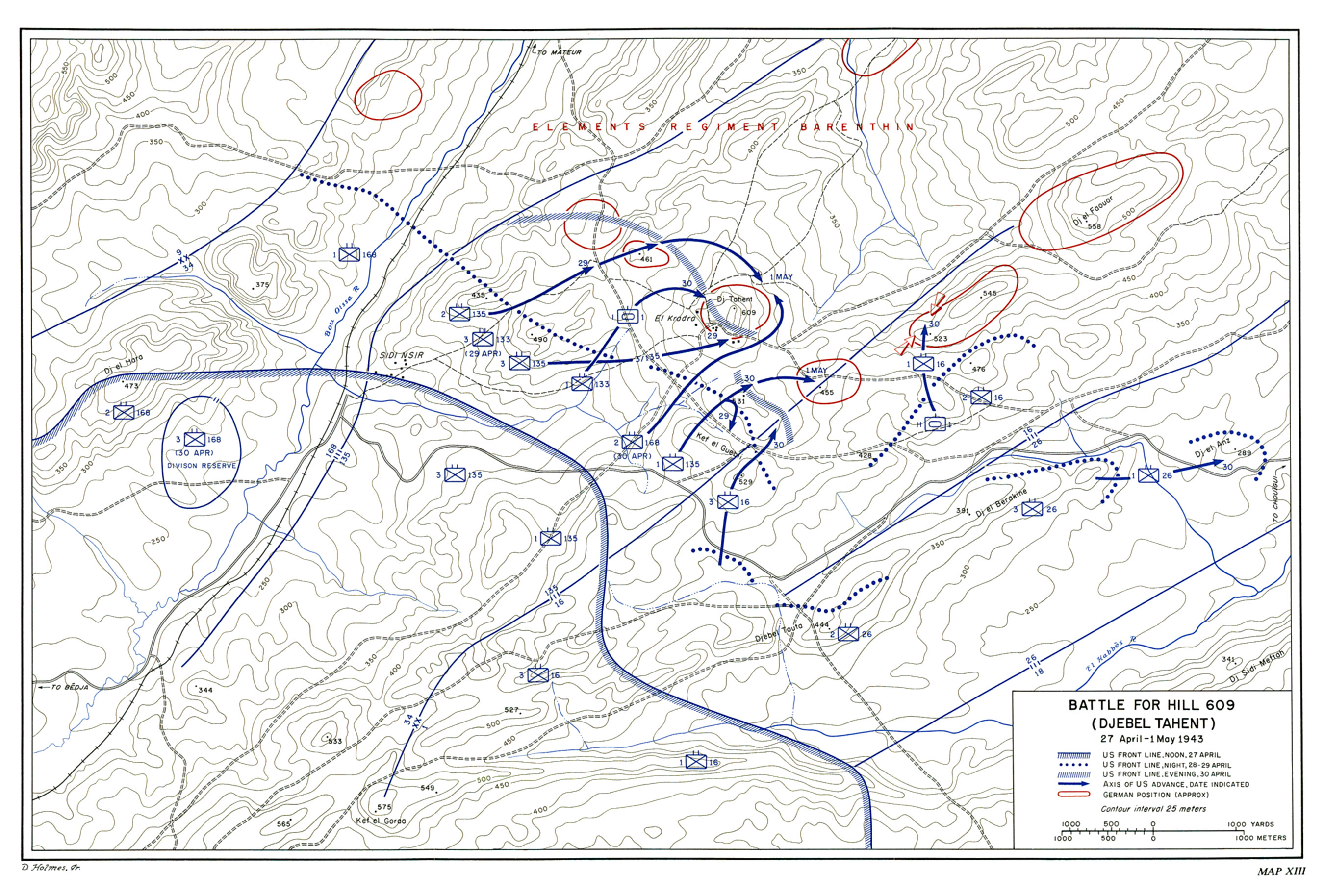

Map XIII
Battle for Hill 609 (Djebel Tahent)
27 April-1 May 1943The 34th Division's attack was expected to continue on a northeast-southwest axis against the westward bulge in the enemy's line along the hills north of the Sidi Nsir-Chouïgui road, and thus to bring under Allied control the heights of Hill 609.1 (Map XIII)
Hill 609
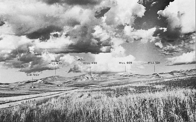
Hill 609's upper contours rising from a much larger, less steeply slanting base, when seen from above, resemble a crude Indian arrowhead pointing toward the east. From tip to base, this arrowhead extends for more than 800 yards, while the distance from the northern to the southern barb approximates 500 yards. Deep notches, bounded by precipitous slopes, pierce the northern and southern sides. Its top is divided into two major areas, a fairly level table rising gradually from west to east in the triangular section between tip and barbs, and an irregular amphitheater falling off to the west, with a narrow level shelf above the white southwestern escarpment. That cliff because of its great height masks from the adjacent ground to the south and southwest the existence of the higher slopes on the western portion of the crest and gives the appearance of a substantial mesa resting on a massive ridge. Low vegetation, mostly bunch grass, growing among rocky outcrops over much of Hill 609, offered little concealment, while the rocky ground made digging in with infantry tools out of the question.2
The triangular eastern section juts up from its base, while the western end rises gradually on the northwest and most steeply of the entire mass on the southwest. There a great palisade, looming brightly in the April sun high above the surrounding ground, was visible to the attacking forces for many miles. An unimproved road crosses the western part of the arrowhead to an Arab village which nestles at the base of the southern notch. Another track skirts the crest at the east, giving access to scattered olive orchards on the lower slopes. Hill 609 is no monadnock but its summit projects at least 200 feet above the crests of any neighboring hills, and it furnished excellent observation over much of the II Corps zone of attack. A British artillery observation post there in February had proved its value.
Hill 609 could be captured and retained only by driving the enemy from adjacent hills which controlled the approaches. A

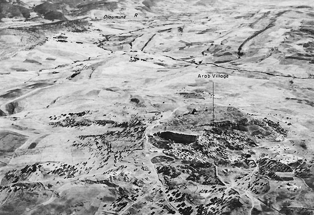
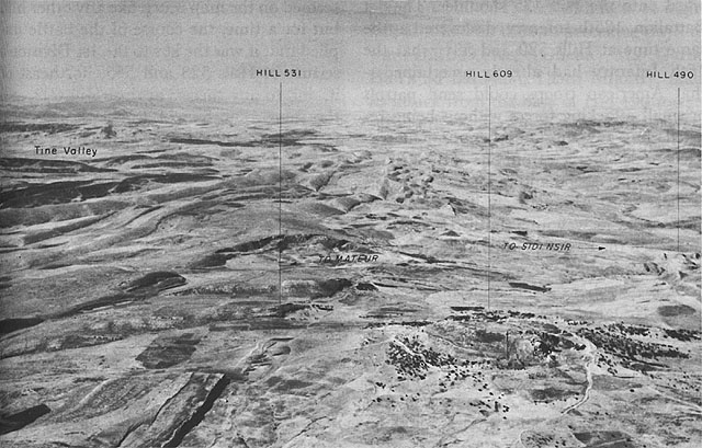
HILL 609, looking north.mountainous mass directly west of the main objective has two great shoulders, Hill 490 and Hill 435 (northwest of Hill 490). A second massif northwest of Hill 609, divided by a narrow defile from Hill 490, is known as Hill 461. Opposite the southeastern quarter of Hill 609 and northwest of the Sidi NsirþChouïgui road is a wide hilly zone with two rows of crests or ridges. An observer on Hill 609 sweeping the horizon from south to east sees the crests designated on the map as Hills 529, 531, 455, 523, 545 and then 558. Almost parallel to these hills and between them and the Sidi NsirþChouïgui road is a lower series of heights rising from a second ridge, of which the most prominent hills are 428 and 476. The contours of these hills are usually rounded except at the northwest, where they are more sharply eroded, so that from Hill 609 this area looks somewhat like a rolling tableland extending back from a steep edge. From the southwest, even from observation points on the shoulders of hills within the American lines, observers could see the upper slopes only on some of these hills, leaving important details of the terrain near their bases to be ascertained by reconnaissance patrols.3
The boundary between the 34th Infantry Division and the 1st Infantry Division cut across this area from the southwest to the northeast in such a way as to require mutual

HILL COMPLEX IN SIDI NSIR AREA, looking northeast.support between the units on either flank.
The boundary sliced across the southeastern slopes of Hill 531, with the smaller part of that mile-long ridge inside General Allen's area, and the rest reaching its highest point at 531 in the attack zone of the 34th Infantry Division. The 16th Infantry could best approach the southeastern portion of Hill 531 by passing through the saddle of Kef el Guebli (529). The regiment could not continue to other assigned objectives to the east and northeast without being subjected to flanking fire from Hill 531. The 1st Battalion, 135th Infantry, could attack Hill 531 only over ground already being occupied by elements of the 16th Infantry. A battalion commander of the 135th Infantry on occasion directed American artillery fire on an enemy target in the 16th Infantry's area. Lt. Col. Robert P. Miller, commander of the 1st Battalion, 135th Infantry, was mindful of the disastrous consequences which a failure of co-ordination could cause because of his own recent experience on the left flank at Fondouk el Aouareb near Djebel Aïn el Rhorab, and he took the initiative in arranging a telephone connection with the command post of the adjacent unit of the 16th Infantry. Regimental liaison was also established. The difficulties of co-ordinated operations in such a complex area severely strained the possible arrangements.4

HILL 609 AREA, looking south, southwest.The Attack Opens
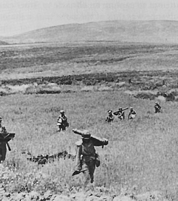
Hill 609 was wholly in the 34th Infantry Division's zone. The strength and the determination with which the enemy would defend his possession of that dominating height, and the nature of the interlocking defense of its satellite hills, were discovered during the first stage of the operations to seize it. General Ryder's initial plan of attack assigned the task of taking the hill to the 135th Infantry (Colonel Ward), which gained control on 26 April of lightly held heights, but discovered almost at once that a direct approach to Hill 609 from the southwest would be strongly resisted from Hill 490 (to the west), Hill 531 (to the south), and from Hill 609 itself. The Americans did not then know that the relatively small forces on these hills would be able to hold them back. General Ryder, after being advised that Hill 609 itself might be "bypassed," approved Colonel Ward's plan to send one battalion against Hill 490 and a second battalion to occupy the part of Hill 529 in the division zone and then continue to Hill 531.5
Neither of these two attacks on the night of 26-27 April was successful. The two battalions gained footholds, but failed to reach their objectives. Hill 490 was won on 28 April only after an additional battalion had been committed and a series of enemy counterattacks had been repulsed. Control over the upper slopes of this large hill mass west of Hill 609 was extended northwestward
onto the Hill 435 shoulder. The 1st Battalion, 135th Infantry, discovered at the same time at Hills 529 and 531 what the 16th Infantry had already ascertained--that American troops could send patrols or small attacking forces without being resisted, but any substantial movement was likely to be observed from one of the heights in enemy possession and to receive prepared artillery fires. Although an attacking force might work its way up a southwestern slope and reach the bare top, once there, it would be pinned down by heavy machine gun fire from a neighboring hill and subjected to severe casualties by enemy artillery air bursts. The enemy used a reverse slope defense, firing his automatic weapons in quick bursts, then ducking for cover, and dropping high trajectory fire into draws and gulches through which attacking troops could be expected to move. Many such areas were mined. Whenever American troops gained a summit and survived the subsequent enemy fire, they could expect counterattacks before they had organized a defense unless they were extraordinarily quick about it. At Hill 529, the enemy had been temporarily driven off the top before noon, 27 April, but Hill 531, the next objective, seemed unattainable a day later, because of the fire which he could place on the hill from various quarters.6 Furthermore, the enemy was able to deliver flanking fire from Hill 531 both eastward upon the 16th Infantry during its operations toward Hill 523 and northwestward over the open area between Hill 490 and Hill 609. Hill 531 seemed on the map much like any other hill, but for a time, the course of the battle implied that it was the key to the 1st Division's seizure of Hills 523 and 545, northeast of it, and to any success against Hill 609, still the main objective of the 34th Division, from the south. On 27 April, General Anderson proposed to General Bradley that Hill 609 be bypassed, but was persuaded that such a move would not be good tactics.7
First Failure and Broadened Plans
The inability of General Ryder's division to seize Hill 609 on 28 April in turn frustrated the 1st Infantry Division's costly attempts on that day to press northeastward as far as Hills 523 and 545, which masked the enemy's line of supply and principal route of reinforcement. General Allen then at 1400 ordered all units under his command to hold up offensive movement pending the capture of Hill 609 by the 34th Division.8 General Ryder next planned to take Hill 609 early on 29 April by envelopment from the north, west, and south. Three interrelated attacks would be made by the three battalions of the 135th Infantry. The 3d Battalion had captured Hill 490 the day before. It was now to advance from this hill behind a rolling barrage to make a holding attack against the southwestern section of Hill 609 while the 2d Battalion gained Hill 461 and swung southeast, and while the 1st Battalion took Hill 531 and attacked northward. Defense of Hill 490 (and Hill 435) was assigned to

TROOPS MOVING TO A NEW POSITION NEAR HILL 609, 28 April 1943.the 3d Battalion, 133d Infantry, attached to the 135th Infantry. These moves were made in the hope that if all three battalions in the assault were to strike Hill 609 simultaneously, the defenders might be taken off balance by at least one of them.9
The plan could not be executed on 29 April. The enemy held positions in the draw between Hill 435 and Hill 461 from which enfilading fire struck the western flank of the 2d Battalion, 135th Infantry, already much weakened by the bitter fighting of the previous day, and pinned it down short of Hill 461. The northern envelopment was thus checked before it was fairly in progress. On the other flank, the 1st Battalion, 135th Infantry, could not get a firm hold at any point on Hill 531, and withdrew at nightfall, as it had on the two preceding days, toward Hill 529 (Kef el Guebli). Maj. Garnet Hall's 3d Battalion, 135th Infantry, made its attack from the base of Hill 490 toward the southwestern quarter of Hill 609 and got across the intervening ground behind a rolling barrage as far as the base of the objective. When the barrage was lifted, however, the enemy counterattacked and forced the Americans back a quarter of a mile. There they reorganized amid rocky outcrops along a low rise and started a second attack with renewed artillery support. This advance brought the troops part way up the hills to the shelf, where many sought cover from alert enemy riflemen and machine gunners among the buildings of the Arab village, and thus passed out of control of the battalion commander. At that stage, darkness fell. The enemy was still in full possession of Hill 609.10
The attack by II Corps in the south had reached a critical point after the failure on 29 April. Casualties included 183 killed, 1,594 wounded, and 676 captured or missing.11 General Allen's battered units were obliged to operate at an enormous disadvantage. The 16th Infantry had been severely punished trying to reach Hill 523. The 26th Infantry, fighting to occupy Djebel el Anz (289), drew flanking fire from Hills 523 and 545 northwest of it. To
attack and hold Hills 523 and 545 before the enemy had been driven off Hill 609 was certain to be costly and likely to prove impossible. Those heights, although not so close to Hill 609, were as exposed to fire as Hill 531. Yet General Allen was not disposed to accept a plan in which his own command had to wait for another to discharge its part of the burden of attack.12 He reasoned that if in addition to Hills 523 and 545, he took another height, Hill 558 (Djebel el Facuar), about 4,000 yards east-northeast of Hill 609, he might thereby enclose Hill 609 in a pocket from which the enemy would feel compelled to withdraw before it became too late. Although the enemy had lost only 408 prisoners, he was weakening, for his troops had been under incessant pressure by substantially greater forces. Furthermore, his reinforcements and supplies were brought in under American observation and fire and his rations and ammunition were running critically low.13 There were other signs that the enemy was resorting to improvisation and persisting under severe strain. In the whole operation from Hill 609 to the Tine river valley, therefore, it was perhaps better to keep pushing everywhere rather than to concentrate on some key objective as a method of winning the battle. It was possible, moreover, that if the enemy failed in his efforts to defend the Hill 609 complex the effort would leave him so depleted that he would be unable to hold firmly the area farther to the northeast. An attempt to capture an obstacle to American advance was thus at the same time a major opportunity for the destruction of the enemy's fighting power.
During the afternoon of 29 April, General Ryder planned an attack with tanks for execution that night and early next day. With one company of medium tanks and a fresh battalion of infantry (the 1st Battalion, 133d Infantry) attached to Colonel Ward's command, that force, jumping off from a point 800 yards east-southeast of Hill 490, was to make a predawn assault with the objective of gaining a foothold on the northwestern slopes of Hill 609 for subsequent infantry exploitation. The tank unit, Company I, 1st Armored Regiment (Capt. Robert D. Gwin), made its own reconnaissance before darkness and devised its own tactical plan, which was co-ordinated with others and approved by General Ryder at one of his daily command conferences within sight of the area to be attacked.14
At the same time, General Allen ordered an attack during the night by the 16th Infantry to seize Hill 523. Hill 523 could not be held unless the enemy was also driven from Hill 545, the next crest to the east on the same major ridge. Colonel Taylor therefore worked out a plan for the 1st Battalion, 16th Infantry (Lt. Col. Charles J. Denholm), to cross the open area south of Hill 523 in darkness and seize its crest before daylight, while the 3d Battalion would clear the southern sector of Hill 531 by pushing north toward the reverse slope where the enemy had dug his positions. The 2d Battalion,
16th Infantry, was to hold itself in readiness to attack Hill 545 at the earliest opportunity.15 These two major attacks on 29þ30 April would be conducted while the 1st Battalion, 135th Infantry, returned to the offensive for the third day in the attempt to clear the northwestern slopes of Hill 531, and while at Djebel el Anz the 26th Infantry improved its positions on the western approach in the face of the enemy's apparent intention to challenge that hold by strong counterattack.
Successful General Attack
30 Aprilþ1 MayOn 30 April American troops reached the summit of Hills 609, 531, and 523 and began to defend these gains against determined enemy countermeasures. As expected, some of these hills proved more costly than others. The early morning attack to reach the northwestern slopes of Hill 609 by Lt. Col. Carley L. Marshall's 1st Battalion, 133d Infantry, and Captain Gwin's Company I, 1st Armored Regiment, was a success. Not only did these units push through, but on their left, the 2d Battalion, 135th Infantry, was able to renew its advance onto Hill 461, and captured it. From there the battalion fanned out to the southeast and by 1100 made contact with Colonel Marshall's battalion. Elements of the latter, which had "grabbed and held onto the tails" of the tanks, cleaned out enemy gun positions. The German defenders knocked out four of the tanks (two of which were recoverable), but the remainder were ready to roll back over the saddle between Hill 490 and Hill 609 in order to mop up.
Colonel Miller's battalion by then was heavily engaged in what proved to be the final attack on Hill 531. Since the small hours of the day the 1st Battalion, 135th Infantry, had made repeated efforts to reach the summit but had failed. The troops had beaten off a series of German counterattacks by making excellent use of well directed artillery fires. But in their own attempt to seize Hill 531 they were at a distinct disadvantage owing to the failure of the 16th Infantry to maintain its hold on Hill 523. The right flank of Colonel Miller's battalion was thus dangerously exposed. At about 1530 Miller's battalion renewed its attack from the slopes of Hill 529 with the mission of capturing Hill 531 and pushing beyond to Hill 455. Covered by an artillery preparation, including smoke, and by mortar and overhead machine gun fire from Hill 529, Company A, 135th Infantry, worked up the northwestern bulge of Hill 531 while Company C fought its way up the southern slopes. At some points, particularly in the center between these two enveloping companies, the hillside rose in steep escarpments and cliffs, which made these attacks up the two flanks necessary. The enemy pressure on Company A's left flank from Hill 609 was greatly diminished by the simultaneous operations against that hill, and the 3d Battalion, 135th Infantry, near the Arab village, assisted the 1st Battalion at Hill 531 by firing on the enemy's reverse slope positions and checking his repeated attempts at reinforcement. The Germans supplemented other weapons by tying together bundles of "potato masher" grenades and dropping them on the attacking troops from higher crags. When Company C was stopped just short of the top by German rifle and machine gun fire, the heavy weapons platoon, from a rocky shelf,
knocked out some of the enemy's fire power by mortar shells and made possible a renewed advance. Company A left its weapons platoon in position on Kef el Guebli (Hill 529) and used most of one platoon as ammunition carriers. Late in the day, the light machine gun squad and a detail heavily loaded with hand grenades crossed from Hill 529 to Hill 531 and climbed to the crest, where the attack was thereupon renewed. By nightfall, 30 April, Hill 531 was "owned" by Colonel Miller's battalion. But Hill 455 still seemed out of reach and the gap between the battalion and its left neighbor, the 3d Battalion, 135th Infantry, was yet to be closed. The simultaneous operations against Hill 609 had prevented the enemy from subjecting the top of Hill 531 to the sort of fire with which the arrival of the Americans might previously have been greeted.16
Hill 523 cost the 1st Infantry Division a heavy price. The hill was taken by the 1st Battalion, 16th Infantry, in a night attack (29-30 April) against light resistance. The approach due north by compass through open fields of short wheat brought the battalion to the base of its objective undiscovered, and it reached the crest in a swift climb under fire, culminating in an assault with hand grenades and knives. By 0445, it had seized the hill. Colonel Denholm's misgivings, which Colonel Taylor had shared, applied to the difficulty which could be expected not in taking, but in holding, the hill. The line of communications would be under enemy fire. The southern slopes of Hill 523 could be observed and struck from Hill 609 to the west and from lower, intermediate knolls in the area of the German stronghold around Hill 455. On the rocky summit of Hill 523, Denholm's men erected parapets for a perimeter defense. Foxholes were out of the question. An attempt to extend control along the heights to the crest of Hill 545 (northeast of Hill 523) was stopped by an unexpected, deep earthquake fault between two parts of the ridge with a gap too wide to jump and sides too sheer and high to climb. Daylight was certain to bring enemy countermeasures which might cut off the battalion. The expected reaction came at dawn in the form of light fire from the southeast and south, and heavy fire from southwest and west. In shelling from the southwest the Germans employed in particular one captured American self-propelled gun or tank destroyer, and several of their own antitank guns for effective direct fire. All wire lines were broken and all radios were shot out so that by midmorning the battalion lost communication with the rear except by courier. During this preparation fire, the enemy organized a counterattack. He swung around the shoulder of the hill from the southwest and simultaneously attacked from the northeast, encircled the men on the hill, and killed or captured them in a wild melée on the summit. The commander and about 150 men were eventually taken prisoner. The rest were killed.17
As soon as he learned that the situation on Hill 523 was critical, General Allen tried to relieve it by sending a company of medium tanks (Company H, 1st Armored Regiment, commanded by Capt. Herbert F. Hillenmeyer), which had been attached to his command. At about the same time, Company I, 1st Armored Regiment, was beginning to work along the southern slopes of Hill 609 from west to east. A combination of enemy mine fields, antitank gun fire, and air attacks and the absence of arrangements for co-ordinated tank-infantry-artillery operations soon frustrated this attempt by Captain Gwin's company and forced Captain Hillenmeyer's company to be redirected to Hill 523 over a longer, slower route. In the interval, other measures to support Colonel Denholm were tried without success. The tanks arrived at approximately 1645. Despite the quick loss of four vehicles to antitank guns, the tank unit then supported a successful small attack to drive the enemy off, but the battalion had been lost. For lack of troops, neither Colonel Taylor nor the enemy could reoccupy the hill in strength.18
By midafternoon on 30 April the fall of Hill 609, after four days of fighting, seemed imminent. The troops of the 1st Battalion, 133d Infantry, which had attacked with the tanks, had built up a co-ordinated defense of the sector to the northwest of Hill 609, tying in with the 2d Battalion, 135th Infantry, on Hill 461. The 3d Battalion, which had spent the night in isolation in the area of the Arab village, sent a patrol around the western slopes of Hill 609. At long last these men got to the summit and established an observation post.19 The Americans had driven the enemy from Hill 609, but their ability to hold it was to be tested by a series of counterattacks during the following night and on 1 May.
During the afternoon of 30 April, the 2d Battalion, 168th Infantry (Lt. Col. Edward W. Bird), was attached to Colonel Ward's command for the last phase of operations against Hill 609. The battalion moved forward to an assembly area north of the Sidi Nsir road about 2,000 yards southwest of Hill 609. Colonel Bird's battalion was directed to advance toward the saddle between Hill 609 and Hill 531, clearing it of the enemy and, by attacking around the eastern and northeastern base of Hill 609, to establish contact with the 1st Battalion, 133d Infantry on its left, while on its right it was to tie in with the 1st Battalion, 135th Infantry on Hill 531. This night assault was ordered for 2300. As the battalion moved toward the saddle and the base of Hill 609 the troops caught by surprise a platoon of enemy infantry trying to infiltrate up the western slopes of Hill 609 behind the lines of the 1st Battalion, 133d Infantry. Before dawn, the Germans sent about a company from Hill 455 to reinforce this advance group. Company F, 168th Infantry, nearest Hill 609, intercepted this attempt to regain the lost position and drove the enemy off with substantial losses. Meanwhile the 1st Battalion, 135th Infantry, had continued its attack in the area of Hill 531 and, after securing the long-contested stronghold, finally closed the gap between it and Hill 609 by also seizing the area of Hill 455 in
the afternoon of 1 May. These operations completed the American ring around Hill 609. German countermeasures on 1 May were ineffective and un-co-ordinated. The enemy undertook a number of desperate efforts to restore his positions, but his movements were now subject to the superb American observation from the very heights which had previously served the German defenders so well. Heavy concentrations from the combined artillery of the 34th and 1st Divisions broke up every enemy attempt to assemble his forces for counterattack.20 A final German effort at dusk ended in failure. By the end of 1 May, the enemy had failed to make a dent in the newly won positions of the American troops.
Approaching "The Mousetrap"
Elsewhere in the area under attack in the southern part of the II Corps zone, the enemy was forced off critical heights, the most noteworthy of which was Djebel el Anz, just north of the Sidi NsirþChouïgui road. The enemy's efforts to retake it reached a climax on 30 April in five unsuccessful counterattacks supported by a last flicker of Stuka attacks and effective fire from 88's. In the possession of the 26th Infantry, Djebel el Anz offered an advantageous position from which to support the 18th Infantry's attack on Djebel Badjar (278), the hill about one mile to the southeast on the opposite side of the road, which guarded the northern side of the narrow Mousetrap exit from the upper Tine valley.21 (See Map XII.)
The operations on the southern side of the Tine valley were geared to the advance of the British 5 Corps farther south, and to the progress of the two infantry divisions fighting between the valley and the area of Hill 609. The tank units of the U.S. 1st Armored Division awaited the signal from General Bradley to emerge from The Mousetrap onto the broader plain near Mateur for the rapid exploitation of success by the infantry in the mountains. When the signal came, Combat Command B would be ready to go. By 1 May, the time seemed very near. Meanwhile, the 6th Armored Infantry, with the 27th, 68th, and 91st Armored Field Artillery Battalions, and reconnaissance troops, fought among a series of shoulders protruding into the Tine valley from Djebel Lanserine (569). Advance was difficult indeed and correspondingly slow, despite determined and often heroic efforts. On 28 April, Company A, 6th Armored Infantry, was held up by enemy machine gunners until Pvt. Nicholas Minue alone boldly crept behind them and cleared them out by bayonet. He persisted against other enemy positions until he was mortally wounded.22
A seesaw struggle in these hills had settled into a deadlock by 1 May. Company D, 16th Armored Engineer Battalion, meanwhile
MATEUR, looking northeast.lifted mines from two routes along the banks of the stream and prepared roadbeds toward the narrows for the armored vehicles. The enemy faced the choice of fighting at a growing disadvantage back through the last narrow segment of hills or of pulling back to a shorter line closer to Bizerte and the hills east of the Tine. His decision was affected by the progress of the 9th Infantry Division's attack in the northern part of the II Corps zone.23
The Enemy Is Forced To Withdraw
1-3 MayThe 9th Infantry Division's attack was conducted, as already noted, according to a revised plan, beginning on the night of 26-27 April. The 60th Infantry then sent its northern elements along the north side of the Sedjenane river toward Djebel Touro (499), converging on the path of advance of the Corps Franc d'Afrique, while its center and right pushed more nearly eastward toward Kef en Nsour (523). Thus the northern envelopment of the Djefna position devolved upon the 39th Infantry alone rather than upon both regiments. The 2d Battalion, 39th Infantry, after four days of assiduous effort under recurrent strong
enemy artillery fire, gained possession of Hill 382, three miles east of Djebel Aïnchouna, at daylight on 30 April, and started toward its next objective only to be pinned down by accurate shelling, obviously directed by some hidden enemy observer. The locations of the firing batteries were established by American observation and confirmed by enemy prisoners, but they were out of range of the supporting American artillery. The mission of neutralizing these batteries was passed to tactical air support, which was unable to find the one which caused most damage.24 While the 2d Battalion, 39th Infantry, was thus held back, the other two battalions moved from Djebel Aïnchouna by trails northeast of it toward a long Hill 406 (Djebel Nechat el Maza) and a smaller, lower mound, Hill 299, south of its eastern extremity. The 1st Battalion took Hill 406 during the forenoon, organized it, and after 1400 supported the attack of the 3d Battalion on Hill 299. By nightfall, Hill 299 was also occupied. It had been possible from Hill 406 to observe enemy vehicles and a supply dump south of Hill 299, and to bring artillery fire upon the area about an hour after the 3d Battalion's attack on Hill 299 began. Possession of that hill, which had a very steep southeastern slope rising from a small plain, made possible domination of the enemy's supply lines. It was a further menace to the enemy as a base from which the Americans could thrust less than three miles eastward onto the open Mateur plain or southeastward to cut the SedjenaneþMateur highway in the rear of Djefna position.25 Plans for a one-battalion attack by the 47th Infantry on Green Hill in conjunction with the 39th Infantry's next spurt were ready when the 9th Infantry Division, on corps orders, suspended offensive movement on 1 May.26
The 60th Infantry struggled northeastward across country along the Sedjenane river, through dense underbrush, with the benefit of few trails or roads, but overcoming the drastic supply difficulties. The attacking forces suffered to such a degree from the enemy's use of the observation points on Kef en Nsour (523) that occupation of that height finally seemed imperative. The 3d Battalion approached Kef en Nsour on 30 April, while the remainder of the regiment held strong positions on and near the Djebel Guermach (490), southwest of it.
On 1 May, therefore, the Allies threatened to cut the enemy off from both Bizerte and Mateur. He was obliged to move speedily from the Djefna position. A retirement on Mateur along the Sedjenane road also necessitated a withdrawal from the hills adjacent to the Sidi Nsir road, in the area surmounted by Hill 609, if the forces there were not to be attacked from the flank and rear. The enemy facing the II Corps thus simultaneously found all his positions west and southwest of Mateur untenable. His forces had become insufficient to close the gaps in his line. The supply situation had become acute. The lack of artillery ammunition was such that at some points in the 9th Infantry Division zone, as early as 29 April, about 90 percent of the enemy's shells which fell failed to detonate either because of defective
fuses or other imperfections.27 On 1 May, only four Siebel ferries and two small craft from Italy reached Tunisian ports, discharging 90 tons of fuel and 60 tons of ammunition. It was a hand-to-mouth situation, with a partly filled hand at that. In the circumstances, the high command chose to pull back the Fifth Panzer Army's line in the sectors of the Division von Manteuffel and 334th Infantry Division, anchoring the northern end in the prepared defenses between the Garaet Ichkeul and the sea, and swinging down the eastern side of the Tine river to Djebel Lanserine.28
By 1 May, the Allies estimated that the enemy, far from evacuating the Tunisian bridgehead, would be resolute in defending it, so that they would have to force him back into separate bridgeheads around Bizerte, Tunis, and Cap Bon, or drive him out altogether. Previous expenditure of enemy reserves was believed to have reduced him to shifting units from point to point to meet Allied threats, but not yet to last-ditch perimeter defense of smaller, isolated areas.29
The enemy skillfully and quietly withdrew on the nights of 1-2 and 2-3 May. The scope of this retirement was suspected on 2 May and confirmed next day. From Hill 609, a large fire was visible in Mateur.30 Elsewhere, explosions and fires indicated the demolition of bridges and destruction of matériel. The northern elements of Division von Manteuffel pulled back more slowly for lack of vehicles rather than as the result of more determined opposition. The U.S. 9th Infantry Division diverted the 47th Infantry from the Djefna position to the area northwest of Garaet Ichkeul and sent the 39th Infantry to high ground west of it.
The Fall of Mateur
3 MayMateur fell on 3 May with dramatic suddeness to the 1st Armored Division, which was finally released after being held for a week on leash. Armored detachments from the division where feasible had assisted from the start in offensive operations with infantry, and had stood in corps reserve ready for a short time to meet an enemy counterattack near Sidi Nsir which was never delivered. They had tipped the scales with the reinforced 135th Infantry in the battle for Hill 609. The 1st Armored Division's zone of attack, in which Combat Command A (Colonel Lambert) had directed operations, had been narrow, and all operations there had been subsidiary. Now the division was to advance out of the upper Tine valley by two cleared routes and, turning northward, to seize Mateur. This operation would not be the classical role of the armored division, exploiting a break-through into the enemy's rear, for the enemy had already pulled back. The maneuver would instead be a rapid pursuit. General Harmon had earlier assigned the mission to Combat Command B under General Robinett.31
The road from the mouth of the upper Tine valley to Mateur runs almost due northward across a series of broad terraces by which the mountainous area of the recent fighting recedes to the plain adjacent to Mateur. The Tine river sweeps farther to the east around the tips of these contours before flowing northeastward toward Mateur. The base of the western hilly area, extending along a northwest-southeast line, forms one boundary of a triangular area of open undulating plain. Across the northern edge of the plain is the Garaet Ichkeul and a dome-like, sentinel height, Djebel Ichkeul (508). The eastern border is marked by another area of rounded hills which extends from the southeastern corner of the Garaet Ichkeul to Chouïgui pass and Eddekhila. In addition to Chouïgui pass, which had been the scene of the first American armored action against German tanks in World War II, these mountains are crossed by a broader trough which connects the Mateur plain with the Garaet el Mabtouha, ten miles east of it. Through this valley run the main highway and railroad linking Tunis and Mateur. Roads connect Mateur with Bizerte by way of either the western or eastern rim of the Garaet Ichkeul. The latter route passes through a very restricted gap at the southeastern corner of Garaet Ichkeul, and continues northward over the narrow strip of land which separates it from the Lac de Bizerte.
In approaching Mateur from the mouth of the upper Tine valley, Combat Command B, 1st Armored Division, crossed the west-east road from Sidi Nsir to Chouïgui northeast of Djebel Badjar. Along this road advance elements of the U.S. 1st Infantry Division emerged from the hills eastward bound at the same time that the armored force was heading northward. Enemy long-range artillery fire was falling close to the junction, where traffic congestion seemed likely to furnish a juicy target. Alert adjustment enabled the two long columns to cross each other without delay, by sending the vehicles of one through the intervals in the other.32 The 81st Reconnaissance Battalion arrived at the edge of Mateur at approximately 1100, with the main armored force rolling up in the early afternoon.
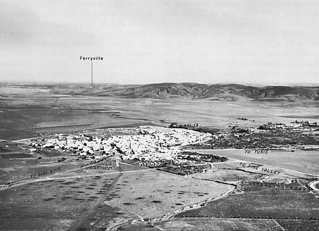
The enemy was demolishing the eastern entrance to Mateur as the Americans arrived from the south and west. A few German and Italian prisoners were taken near Mateur but most of the enemy had disappeared in the direction of Ferryville or into the hills south of Lac de Bizerte. Elements of Combat Command B forded the stream east of Mateur to mop up the town while others reconnoitered to the northwest and northeast. General Harmon sent forward the bridge train of the 16th Armored Engineers, and by 2130, that unit had the first of five crossings in operation despite constant artillery shelling, which continued for the next two days, supplemented by air attacks. Combat Command A began its preparations to move up next day. General Harmon's command post was set up about eight miles southwest of Mateur, and from it he issued orders to reconnoiter on 4 May north and east of Mateur. The 9th Infantry Division in the vicinity of Djebel Ichkeul, the 1st Infantry Division along the Tine
1ST ARMORED DIVISION TANK speeding toward Mateur, 3 May 1943.river southeast of Mateur, and the 34th Infantry Division along the road to Chouïgui pass and Eddekhila, also re-established contact with the enemy.
The U.S. 3d Infantry Division (less 7th Regimental Combat Team), commanded by General Truscott, was brought eastward as far as Aïn M'lilla, about thirty miles south of Constantine, to pass from U.S. Fifth Army to British First Army reserve. From 3 May on, its units came under General Anderson's control in the Rhardimaou-Souk el Arba area, not necessarily to be committed in the II Corps area, but to be available where most needed.33 For the infantry, the prospect was another series of attacks in the hills. The armored division near Mateur had the valley toward Garaet el Mabtouha and the flats adjacent to Garaet Ichkeul and Lac de Bizerte on which to operate, but the adjacent heights in enemy possession undoubtedly held strong antitank positions which would make themselves felt when, after reconnaissance, II Corps resumed its attack.34
Table of Contents ** Previous Chapter (32) * Next Chapter (34)
Footnotes
1. (1) 168th Inf Hist, 1943. (2) 168th Inf FO 15, 26 Apr 43. (3) Maj Ross P. Thrasher, Operations of the 2d Battalion, 168th Infantry, at Hill 473 (Djebel el Hara), 26þ28 Apr 43, MS. The Infantry School, Fort Benning, Ga., 1949þ50.
2. Foxholes were blasted out with "bee-hive" explosive charges by American troops at many of the hills in this zone.
3. (1) Geog Sec Gen Staff Map 4225 (Tunisia), 1:50,000, Sheets 11, 12. (2) Aerial and ground photos by Lt Col John C. Hatlem (USAF). OCMH.
4. (1) Report of Activity of 1st Battalion, 135th Infantry, Vicinity of Hill 531, dated 10 May 43, in 3d Bn 16th Inf AAR. (2) Ltr, Col Robert P. Miller to author, 14 Jan 51, with incls. (3) Ltr, Brig Gen George A. Taylor (Ret.) to author, 22 Nov and 20 Dec 50. (4) Ltr, Col Landon to author, 27 Jan 51.
5. (1) Interv with Col Ward, 30 Nov 50. (2) Ltr, Col Miller to author, 14 Jan 51, with incls. (3) Interv with Gen Caffey, 21 Feb 50. (4) 34th Div FO 35, 26 Apr 43, and FO 36, 27 Apr 43.
6. (1) Msg, Capt Fanning (CO Co C 135th Inf) to Bn Comdr, 1125, 28 Apr 43, Incl 4 to Ltr, Col Miller to author, 14 Jan 51. (2) Ltr, Col Landon to author, 27 Jan 51. (3) Msgs, 0700, 28 Apr 43, Entries 11þ13, and 0930, 28 Apr 43, Entry 23, in 1st Div G-3 Jnl.
7. (1) See II Corps plans as arranged between General Bradley and Generals Allen and Ryder, and recorded next morning in Entry 231, 28 Apr 43, in II Corps G-3 Jnl. (2) Bradley, A Soldier's Story, pp. 85-87.
8. Msgs, 28 Apr 43, Entries 13, 14, and 83, in 1st Div G-3 Jnl.
9. 135th Inf Hist, Sec. IV, Pts. e, f.
10. (1) Interv with Col Ward, 30 Nov 50. (2) 135th Inf Hist, 18 Oct 42þ15 May 43, pp. 12þ13. (3) Maj Arnold N. Brandt, Operations of the 1st Battalion, 135th Infantry, at Hills 609 and 531, 26 Aprþ2 May 43, MS. The Infantry School, Fort Benning, Ga., 1947þ48.
11. Half of the wounded (781) had been evacuated. Strength remained 95,194. II Corps Weekly Rpt, 30 Apr 43, copy in II Corps G-4 Jnl.
12. Memo, Maj Gen Terry Allen (Ret.) for Chief of Mil Hist, 4 Jan 51. OCMH.
13. (1) Msgs, 29 Apr 43, Entries 30, 31, 36, and 41 in 1st Div G-3 Jnl. (2) Ltr, Maj John A. Lauten (then S-2, 16th Inf) to Gen Taylor, 28 Dec 50. Copy in OCMH. (3) Army Group Africa, Sitreps, 28-29 Apr 43.
14. (1) 34th Div FO 37, 2000, 29 Apr 43. (2) Memo, Capt Gwin for CO 3d Bn 1st Armd Regt, 14 May 43, sub: Opns of Co I while attached to 34th Div near Sidi Nsir 30 Aprþ4 May 43, in 3d Bn 1st Armd Regt AAR.
15. Opns Overlay for CT 16 Attack, 29 Apr 43, Entry 41, in 1st Div G-3 Jnl.
16. (1) Brandt, Operations of the 1st Battalion, 135th Infantry . . . 26 Aprþ2 May 1943, MS. The Infantry School, Fort Benning, Ga., 1947þ48. (2) Ltr, Col Miller to author, 14 Jan 51, with incls. (3) 135th Inf Hist, Sec IV.
17. (1) Msgs, 0445, 30 Apr, Entry 4, and 1034, 30 Apr 43, Entry 27, in 1st Div G-3 Jnl. (2) Cf. Maj Robert E. Cullis, Operations of the 1st Battalion, 16th Infantry, in the Attack on Hill 523, Vicinity of Mateur, 30 April-1 May 1943, MS, and Maj David Milotta, same title, MS. The Infantry School, Fort Benning, Ga. Cullis was then the executive officer of the 16th Infantry, and Milotta was a platoon leader in Company A, 16th Infantry. (3) Intervs with Cols Mason and Gibb, 13 Nov 50, and with Col Crawford, 16 Nov 50.
18. (1) Ltr, Gen Taylor to author, 20 Dec 50. (2) Ltr, Col Denholm to author, 13 Dec 50. (3) 1st Div G-3 Jnl, 30 Apr 43, particularly Entries 29, 45, and 59. (4) Intervs with Cols Mason and Gibb, 13 Nov 50.
19. (1) 135th Inf Hist, Sec. IV, p. 13. (2) 1st Bn 133d Inf AAR in 34th Div Opns Rpt, 11 Decþ15 Jul 43.
20. (1) 168th Inf Hist, 1943, pp. 46þ47. (2) 135th Inf Hist, Sec. IV.
21. (1) 26th Inf AAR, 14 Aprþ9 May 43. (2) 26th Inf Jnl, 30 Apr 43. Casualties: four killed, twenty-nine wounded. (3) 1st Div G-3 Jnl, Entries 18 and 20, 30 Apr 43.
22. For this heroic exploit, he was posthumously awarded the Congressional Medal of Honor. Howe, Battle History of the 1st Armored Division, pp. 232-33.
23. (1) 1st Div G-3 Jnl, 1 May 43. (2) 135th Inf Hist, Sec. IV, p. 14. (3) 6th Armd Inf Hist, 14 May 43; 6th Armd Inf AAR, 2 Sep 43. (4) 1st Armd Div AAR, 3 May 43.
24. Reconnaissance at 4,500 feet for ten minutes proved unavailing. Air Support Party Jnl, 27 Apr 43, in Msg, 2 May 43, Entry 31, in II Corps G-3 Jnl.
25. (1) 9th Div AAR, 27-30 Apr 43, 10 Sep 43. (2) 60th Inf Hist, 1943, pp. 38-42. (3) Msgs, 30 Apr 43, Entries 71, 78, 119, and 123, in 39th Inf Jnl.
26. 9th Div AAR, 30 Aprþ1 May 43, 10 Sep 43.
27. (1) 9th Div AAR, 10 Sep 43. (2) Msgs, 29 Apr 43, Entries 64 and 69, in 39th Inf Jnl.
28. (1) Daily Rpt, Army Group Africa to OKH/GenStdH, 1 May 43, in Army Group Africa, Sitreps. (2) MS # D-001 (von Vaerst).
29. 1st Armd Div G-2 Est, 2400, 30 Apr 43.
30. Msg, 0610, 3 May 43, Entry 9, 1st Div, G-3 Jnl.
31. The 1st Armored Division reported 52 light and 154 M4 medium tanks operational at noon, 3 May 1943. See Msg, 3 May 43, Entry 100, in II Corps G-3 Jnl. Combat Command B, 1st Armored Division, then consisted of: Headquarters, Combat Command B; 13th Armored Regiment (less 1st Battalion); 776th Tank Destroyer Battalion; Company C, 16th Armored Engineer Battalion; 1st Battalion, 6th Armored Infantry; 27th Armored Field Artillery Battalion--a force which included 18 75-mm. tank destroyers and over 100 medium tanks.
32. Robinett, Among the First, MS, p. 495. In private possession.
33. (1) Memo, Col B. M. Archibald for G-3 AFHQ, 27 Apr 43, sub: Rpt of visit to 18 A Gp. AFHQ Micro Job 10A Reel 6C. (2) Msg 0814, 18 A Gp to AFHQ, 29 Apr 43; Msg 8040, AFHQ to Fifth Army, 29 Apr 43; Msgs, 18 A Gp to FREEDOM, 3 and 14 May 43; Msg E-1516, EBS to FREEDOM, 8 May 43. AFHQ CofS Cable Log.
34. (1) II Corps AAR, 15 May 43. (2) Phone Convs, CG 1st Armd Div with G-3 and Asst G-3 II Corps, 0710, 0923, and 1050, 3 May 43, Entries 67, 73, and 78, in II Corps G-3 Jnl. (3) Bradley, A Soldier's Story, pp. 90-91. (4) 1st Armd Div AAR, 13 Apr-14 May 43.