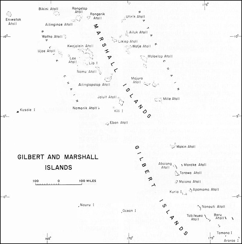
The Washington conference of May 1943 (TRIDENT) set forth the general outline of proposed operations in the Pacific for the second half of 1943 and for 1944, but much work, thought, and discussion remained before detailed plans could be devised to carry out these broad concepts. Two main problems were still to be decided. The first of these was the choice of exact targets within the Marshalls group. The group consists of a double chain of coral atolls lying between latitude 5° and 15° north and longitude 162° and 173° east. There are altogether thirty-two islands and atolls and some selection had to be made between them.1 Also, the possibility early presented itself that the Marshalls might best be approached by way of the Gilberts, a group of sixteen islands and atolls formerly belonging to the British and lying athwart the equator in the general area of longitude 173° east.2 (See Map 2)
More difficult of solution was the second problem, which involved the balance and co-ordination of the Allied offensive as between the Central Pacific theater and General MacArthur's Southwest Pacific Area. Although the "Strategic Plan for the Defeat of Japan" had clearly indicated that the "main effort" in the westward advance would be through the Central Pacific, there were still those among the various planning staffs in Washington--in addition of course to General MacArthur himself--who doubted the wisdom of giving the Central Pacific offensive priority over MacArthur's proposed drive against Rabaul. These doubts had to be resolved or the objections overruled before final plans for a Marshalls operation could be developed. Any troops, aircraft, and shipping that were to be made available to the Central Pacific drive would have to be diverted from the pool either already under MacArthur's control or potentially assignable to his theater. It was to these delicate and difficult problems that planners in Washington addressed themselves in June and July of 1943.
Work began immediately after the Washington conference. On 27 May the Joint Staff Planners directed the Joint War Plans Committee to estimate the forces required for an invasion of the Marshalls and to recommend target dates.3 The War Plans Committee promptly delivered a preliminary report suggesting that the invasion
Map 2:
Gilbert and Marshall Islandsof the Marshalls be carried out in three phases: (1) seizure of Kwajalein, Wotje, and Maloelap Atolls in the center; (2) occupation of Eniwetok and Kusaie as outposts to the north and west; and (3) mopping up to seize or neutralize the entire Wake-Gilberts-Marshalls system. The operation, it was recommended, should be launched toward the end of October to coincide with planned Burma operations. Since the initial attacks against the Marshalls would be the first attempt in U.S. military history to assault defended atolls, it was believed that "battle-tested shock troops with amphibious training" totaling one corps of two divisions would be needed for the first phase. The committee recognized that the best assault craft
for the invasions would be amphibian tractors (landing vehicles, tracked) which, when launched from tank landing ships outside the range of shore batteries, could deploy and proceed shoreward without much danger of being stopped by the fringing reefs so abundant in that part of the world.
The only available battle-tested amphibious troops were the 1st Marine Division in the Southwest Pacific and the 2d Marine Division in the South Pacific, although it was thought possible to substitute the 7th Infantry Division for one of the Marine divisions once the Aleutian operations were concluded. Invasion of the Marshalls in October would necessarily deprive MacArthur and Halsey of their only amphibious divisions with combat experience and thus require that South-Southwest Pacific operations be halted by early August. The Joint War Plans Committee therefore recommended that MacArthur and Halsey be ordered to conduct a holding action along the line Russell Islands-Woodlark-Kiriwina-Buna until the Marshalls operation was concluded.4
The proposition that MacArthur and Halsey merely conduct a holding action until the conclusion of the Marshalls operation was met with little favor in the Operations Division of the War Department General Staff or by General MacArthur. Members of the Operations Division argued that for both political and military reasons MacArthur's campaign against Rabaul (CARTWHEEL) should not be impeded. Halting this campaign, it was held, would cause difficult political repercusssions "both in Australia-New Zealand, and in this country." On the military side, any such cessation of the offensive would decrease pressure on the Japanese, warn them that they would be attacked elsewhere, create a lull in an area where Allied air operations were most effective, and eliminate operations tending to relieve pressure on Burma. A defeat in the Marshalls, continued the Operations Division's thesis, would leave the United States for a time without forces to bring pressure on Japan, and might expose the line of communications to the Southwest Pacific. If forces were transferred from MacArthur's area to Nimitz', any stalemate that might develop in the Marshalls could only result in an interval of complete inactivity. The commitment of all available amphibious equipment would postpone for a long time the renewal of amphibious operations in the South-Southwest Pacific. There were other logistical difficulties as well. There probably would not be enough cargo ships and transports. Besides, delivery of amphibian tractors (LVT's) in quantity had just begun, and it was doubtful that enough would be ready by October. Success in these operations would be dependent on this "new and untried type of equipment," and the troops would need to be trained in its use.5
Both the Joint Planners and the Joint Chiefs of Staff agreed that MacArthur's campaign against Rabaul should not be interrupted but concluded that the Central Pacific drive could be launched concurrently anyway. The Joint War Plans Committee was ordered to prepare a plan for an offensive against the Marshalls to be executed in November or December of
1943, but with the understanding that MacArthur's campaign should proceed according to schedule.6 The Joint Chiefs directed Nimitz to prepare a tactical plan for seizing the Marshalls and submit it to Washington. They also radioed MacArthur explaining to him that more extensive operations in the Pacific were warranted by the increasing Allied naval strength, and that they were contemplating invading the Marshalls about mid-November, employing the 1st and 2d Marine Divisions plus all assault transports and cargo ships and the major portion of naval forces from Halsey's area.7
General MacArthur's response was immediate and unfavorable. On 20 June he radioed the Chief of Staff that he was disturbed over the effect the proposed invasion of the Marshalls would have on future operations in the South and Southwest Pacific. Withdrawal of the two Marine divisions would prevent the ultimate assault against Rabaul toward which his current operations were leading. He refused to accept the proposition already agreed to by the joint planners in Washington that the main effort against Japan should be made through the Central Pacific. On the contrary, he argued that "a diversionary attack [in the Marshalls] would of course assist the main effort in this theater [Southwest Pacific]," but that troops should come from the continental United States, "rather than be subtracted from the main attack to the extent that may result in its collapse . . . . I am entirely in ignorance regarding the discussions and decisions of the recent Washington conference and request that I be advised in this respect insofar as it affects the broad concept of operations in this theater . . . . " MacArthur went on to urge the principles of the RENO plan, long cherished by his headquarters. "From a broad strategic viewpoint," the best method of defeating Japan would be to move from Australia through New Guinea to Mindanao with "utterly essential" land-based air support all the way. In this fashion could Japan best be cut off from her conquered territory. An attack through the Marshalls, he argued, would involve a series of carrier-supported amphibious attacks against objectives defended by naval units, ground troops, and land-based aircraft. He made reference to Midway as an example of what he considered such folly.8 "Moreover," he maintained, "no vital strategic objective is reached until the series of amphibious frontal attacks succeed in reaching Mindanao."9
In the end, none of these arguments was deemed compelling enough to dissuade the Joint Chiefs of Staff from their intention to launch the Central Pacific drive in 1943. But the fear of diverting too large a force from MacArthur's theater was primarily responsible for the eventual decision to initiate that drive against the Gilberts rather than directly against the Marshalls.
Even before the receipt of General MacArthur's radiogram, the Joint War Plans Committee had proposed as a possible alternative to a direct strike against the Marshalls the preliminary capture of islands in the Gilberts as well as Nauru, some 390 miles to the westward. The committee's general concept embraced simultaneous
landings on Nauru, and on Makin and Tarawa in the Gilberts, to be covered by carrier attacks against other Japanese bases in the Gilberts and Marshalls. These islands, once secured, could then be employed as air bases from which to attack the Marshalls and reconnoiter the Carolines. Invasion of the Gilberts and Nauru would require, in addition to naval forces, one Marine division and one regimental combat team, several amphibian tractor battalions and other reinforcing units, five heavy bomber squadrons, and one fighter group. The committee still considered this approach to be inferior to a direct invasion of the Marshalls, but recommended that it be undertaken if enough forces could not be mustered for the Marshalls.10
This proposal to attack the Gilberts rather than the Marshalls found immediate favor with the Operations Division. It would obviously require fewer forces and thus be less likely to interfere with MacArthur's plans. Although recognizing that heavy and medium bombers for the Gilberts could only be provided by taking them from somewhere else, the division nevertheless expressed itself to Col. Frank N. Roberts, then acting as Army member of the Joint Staff Planners, as favoring this alternative plan.11
While various staff planners were thus approaching what might be considered a compromise between the Central and Southwest Pacific concepts of strategy, the idea of giving priority to the Central Pacific once again received strong support on 28 June when the Joint Strategic Survey Committee presented its views of Pacific strategy to the Joint Chiefs of Staff. This committee, consisting of Lt. Gen. Stanley D. Embick of the Army, Vice Adm. Russell Willson of the Navy, and Maj. Gen. Muir S. Fairchild of the Army Air Forces, pointed out that the Allies in the South and Southwest Pacific, by driving northward against Rabaul, had been attempting to reverse the polarity of the Japanese campaign of early 1942. This reversal held "small promise of reasonable success in the near future." The committee therefore recommended that a campaign in Nimitz's area be given priority over MacArthur's campaign against Rabaul. Only in operations against the Marshall and Caroline Islands, argued Embick, Willson, and Fairchild, was there a chance to use the fleet to best advantage. Central Pacific advances would also support the defense of Australia and shorten the line of communications to the Southwest Pacific. The Strategic Survey Committee therefore recommended that seizure of the Marshalls and Carolines, which it regarded as the best action that could be inaugurated in 1943, be the first step in the drive toward the Celebes Sea.12
Next day this committee sat with the Joint Chiefs and discussed the suggestions. Admiral William D. Leahy, always a strong supporter of MacArthur and his strategic ideas, pointed out that granting priority to the Central Pacific would be a "complete reversal" of existing policy and projected plans.13 On the other hand Admiral King, expressing dissatisfaction with the slow "inch-by-inch" progress to date, asserted that although Rabaul was important, Luzon was even more so, and that
the latter could best be approached by way of the Japanese Mandated Islands and the Marianas. The Joint Chiefs then turned over the committee's recommendations to the Joint Staff Planners for further study.14 What emerged was in general a vindication of the Central Pacific concept, with the qualification that the first steps in that direction be made by way of the Gilberts.
On 19 July the Joint Staff Planners submitted to the Joint Chiefs a long analysis summing up the relative importance of Central and Southwest Pacific operations as well as a draft of a directive to Admiral Nimitz. The Staff Planners recommended that continued pressure be applied against Rabaul and then in detail spelled out the reasons for the desirability of a concurrent push through the Central Pacific. Such a move, they argued, would have advantages:
it would force the Japanese to disperse their air strength;
it would allow the United States to use its superior naval forces in an area where enemy ground and air forces were weak; and
it would enlarge the Allied front facing the Japanese and at the same time take place near enough to the Solomons to allow naval forces to support operations in either or both areas.
The first step in the Central Pacific drive, they recommended, should be an invasion of the Gilberts and Nauru. Good air photographs of the Marshalls would be required before an invasion there, and the islands to the south would provide convenient bases for air reconnaissance. Capture of the Gilberts and Nauru, however, was considered only a preliminary to the main offensive against the Marshalls and Carolines--a drive already agreed on by President Roosevelt, Prime Minister Churchill, and the Combined Chiefs of Staff. The Staff Planners therefore recommended that the Gilberts and Nauru be invaded by Admiral Nimitz' forces about 1 December 1943.15
Next day (20 July) the Joint Chiefs of Staff met to discuss this analysis. Once again Admiral Leahy expressed his sympathy with MacArthur's point of view by insisting that the proposed Central Pacific drive not be allowed to "interfere with . . . operations being conducted by General MacArthur . . . ." To this Admiral King replied that the invasion of the Gilberts would augment rather than curtail MacArthur's campaigns. General Marshall added that the United States could ill afford to let her great carrier forces in the Pacific stand idle and agreed that a campaign in the Central Pacific would be helpful to MacArthur's planned offensive against Rabaul. General Henry H. Arnold, the commanding general of the Army Air Forces, agreed with the concept behind the new offensive and stated that four additional bomber squadrons could be provided. The Joint Chiefs thereupon approved the Joint Planners' directive but, on Admiral King's motion, set 15 November rather than 1 December as the date for the invasion of the Gilberts.16
The Joint Chiefs sent Nimitz his orders the same day. He was instructed to organize and train necessary forces, to "capture, occupy, defend, and develop bases in the GILBERT GROUP and NAURU" on 15 November, and to occupy other islands and develop "airfields and facilities thereon" as necessary to support the invasion of the principal objectives. All surface forces of the Pacific Fleet
were available to Nimitz. The Joint Chiefs estimated he would require five modern battleships, seven old battleships, seventeen carriers (including four light and seven escort carriers), and twelve cruisers, plus thirty-seven troop transports and cargo ships as well as other amphibious craft assigned the Central Pacific. Air units would include all Pacific Fleet naval aircraft except those in the South and Southwest Pacific, in addition to elements of the Seventh Air Force and the additional bomber groups. Ground troops would include the 2d Marine Division and one Army division not yet designated, three Army aviation engineer or construction battalions, one port battalion, and three Marine defense battalions. Task force commanders would be appointed by Nimitz. The general concept, the Joint Chiefs announced, involved mounting out the task forces from Pearl Harbor and the Fijis, or from both, and seizing the target areas in simultaneous attacks. CARTWHEEL would meanwhile be continued.
Purpose of the invasion of the Gilberts and Nauru, the Joint Chiefs told Nimitz, was "to improve the security of lines of communication," "to inflict losses on the enemy," and "to prepare to gain control of the Marshalls." They therefore ordered him to prepare plans for seizing the Marshalls about 1 February 1944, under the assumption that MacArthur would be operating against positions in New Guinea, the Admiralties, and New Ireland about the same time.17
With the transmission of these orders to Nimitz, there remained but one problem--selection of the other division for the Gilberts. Admiral King for some time had been advocating withdrawing the 1st Marine Division from the Southwest Pacific, and General Marshall for some time had been opposing its withdrawal.18 On 22 July King wrote Marshall to urge withdrawal of the 1st Marine Division and of the 3d Marine Division from the South Pacific to "avoid the inevitable consequences of 'mixed forces.' The Marines are by tradition, experience, and training eminently suited for amphibious operations," especially on the small islands of the Central Pacific as contrasted with the large land areas in the South and Southwest Pacific.19 Marshall replied seven days later. He pointed out that removal of the two Marine divisions would cause profound dislocations in shipping as well as seriously affect CARTWHEEL. In his view, the 27th Division in Hawaii was the only unit, Army or Marine, that could be made available without creating great shipping problems. It had not yet received its first amphibious training but Marshall, stating that amphibious training could start at once and that by November the division should be able to render good service, offered the 27th Division.20
This offer must have satisfied King, for on the last day of July Marshall was informed that King acceded to the employment
of the 27th Division in the Gilberts-Nauru operation.21
With the preparation of the directive of 20 July and the designation of ground combat forces, then, the Joint Chiefs of Staff had laid the strategic groundwork for launching the Central Pacific drive that would eventually bring American and Allied forces almost to the doorstep of Japan. Tactical planning for the operation was left to the theater commanders involved. The code name established for the operation was GALVANIC.
Planning for GALVANIC
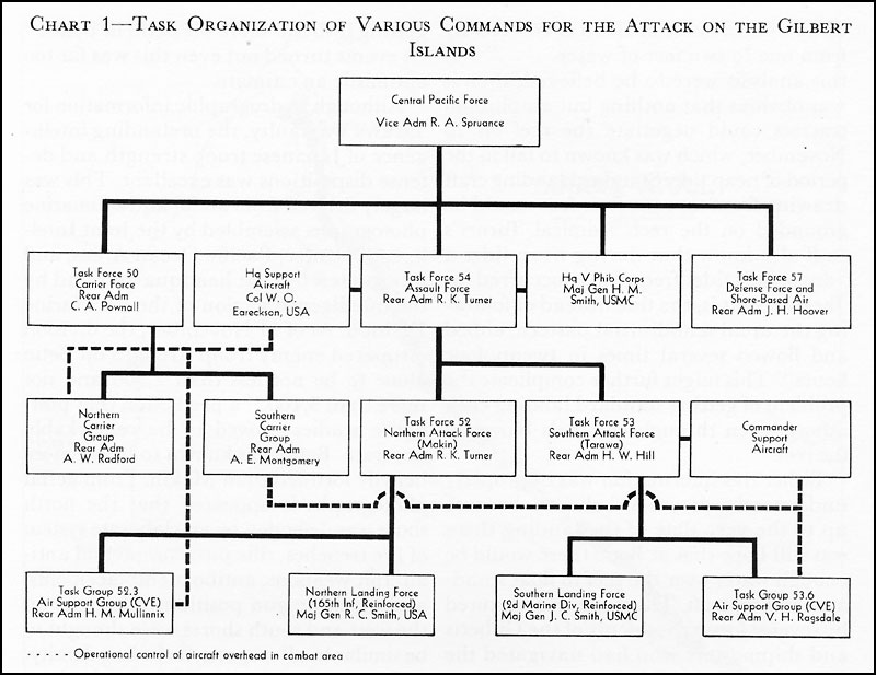
Planning and training responsibilities for the forthcoming landings fell eventually to six separate headquarters. As in all Pacific operations outside of General MacArthur's theater, Admiral Nimitz, as Commander in Chief, Pacific Fleet and Pacific Ocean Areas (CINCPAC-CINCPOA), exercised supreme command and held ultimate responsibility for the success of the endeavor. Next in the chain of command was Vice Adm. Raymond A. Spruance, then designated Commander, Central Pacific Forces, the highest operational fleet command in the theater. Under him was the Fifth Amphibious Force, an organization that was established on 24 August 1943 and commanded by Rear Adm. Richmond Kelly Turner.
For purposes of training and controlling the troop elements of future amphibious landings in the Central Pacific, a separate command was created on 4 September 1943. This was the V Amphibious Corps, commanded by Maj. Gen. Holland M. Smith, USMC.22 For this particular operation General Smith had at his disposal the 2d Marine Division, commanded by Maj. Gen. Julian C. Smith, USMC, and the 27th Infantry Division, commanded by Maj. Gen. Ralph C. Smith, USA, both of whom prepared their own tactical plans for assaulting their separate targets.
Responsibility for preliminary training and logistical supply of the Army troops committed to the operation fell to the headquarters of the Commanding General, Central Pacific Area, Lt. Gen. Robert C. Richardson, Jr., USA. This organization was activated on 14 August 1943 and was charged among other things with the duty of administering and training all Army ground forces and Army air forces in the Central Pacific, subject to the direction of Admiral Nimitz.23
In view of the fact that both the Fifth Amphibious Force and V Amphibious Corps were undergoing organization during the planning phase of the Gilberts operation, much of the burden of devising tactical plans for the troops fell originally to the staffs of the two divisions involved, the 27th Infantry Division and the 2d Marine Division. Both were under some handicaps. The 2d Marine Division was stationed in New Zealand. Its commanding general, General Julian Smith, had been alerted by Admiral Spruance early in August to the fact that the capture of Tarawa and Apamama (Abemama) Atolls would be assigned to his forces, but not until 15 September was the division formally attached to V Amphibious Corps
and not until 2 October did General Smith and his staff personally report to General Holland Smith, the corps commander, in Pearl Harbor.24 Meanwhile, the division staff prepared its own plans, which were eventually approved with modifications by the corps commander.
For the 27th Infantry Division, tactical planning for its particular task was complicated by a midstream change of objectives. The original directive from the Joint Chiefs of Staff had assigned the entire division to the capture of Nauru. Acting on this directive, the division's staff proceeded to gather intelligence data about that island from various sources and by early October had devised a tentative plan of attack employing two regiments in the assault with the third regiment (less one battalion) in floating reserve. Landing beaches were laid out on the northwest coast of the island.25
Meanwhile, higher headquarters were beginning to doubt the feasibility of attacking Nauru at all. On 19 September V Amphibious Corps submitted a revised estimate of the situation that "envisaged considerable difficulty in the capture of Nauru" with the forces made available. After further study in conjunction with the various Navy echelons involved, it became evident that the original concept of GALVANIC should be revised. Nauru offered too many hitherto-unsuspected hazards for an amphibious attack at this particular time. It was about 390 miles west of the westernmost of the Gilberts and hence would place an additional strain on available shipping. Simultaneous landings in the two places would furthermore necessitate a wide dispersal of supporting fleet elements--a dangerous division of forces in view of the presumed possibility of a Japanese naval counterattack. Finally, the precipitous terrain on Nauru would make an amphibious assault and the land fighting thereafter too costly to be warranted by the strategic advantages to be gained. Makin Atoll was considered no less suitable than Nauru as an air base for operations against the Marshalls and was thought to be considerably less well defended. Furthermore, the fact that it was only about 105 miles north of Tarawa made it possible to concentrate the supporting fleet in one area and thus avoid the danger of excessive dispersion.26
Hence, on 24 September Admiral Spruance recommended to Admiral Nimitz that the projected invasion of Nauru be dropped and that an amphibious landing on Makin be substituted. After obtaining the consent of the Joint Chiefs of Staff, Nimitz accepted this recommendation, and early in October a revised plan was issued to his command.27 Spruance was ordered to seize Makin, Tarawa, and Apamama, to cover the amphibious landings on each of these targets with air and naval surface forces, and to deny to the enemy use of land bases in the Marshalls and on
Nauru during the operation.28 D Day for the landings was originally set as 19 November 1943. A month later this was postponed one day, to 20 November.29
Intelligence on the Gilberts
From the very outset of the planning phase of the Gilberts operation, the chief hurdle to be overcome was the initial absence of much reliable information about the physical nature of the target islands and of the disposition of the enemy defenses thereon. The most critical gap in American intelligence, and one never satisfactorily filled, was the lack of any very precise hydrographic data. Charts published by the Navy's Hydrographic Office were so out of date and so inaccurate as to be worse than useless. Also, published tide tables were sketchy in the information they contained. They listed only a few of the Central Pacific islands and for these the figures given for high and low tides were in reference to points as distant as Valparaiso in Chile and Apia in Samoa, thus rendering them highly unreliable.30
It is axiomatic that in amphibious operations reasonably accurate data on tides and on hydrographic conditions offshore of the proposed landing beaches are essential. On such information hinges the solution to such important problems as what is the best time of day, month, and year to launch the operation, what beaches are most accessible, and what type of landing craft can be employed to get troops ashore in proper order with a minimum danger of capsizing, grounding, broaching, or being swept off course by tidal currents.
In obtaining this essential information, as well as intelligence of the probable number and disposition of enemy troops and defense installations on the islands, intelligence officers of the appropriate staffs had to rely on three main sources--aerial reconnaissance, submarine reconnaissance, and reports from British citizens who had lived or traveled in the Gilberts.
Photographic coverage of Tarawa was made on 18-19 September and on 20 October, and of Makin on 23 July and 13 October. Excellent vertical and oblique shots of Tarawa were obtained, both of great value in studying beaches and locating weapons and installations. For Makin, the vertical photographs were good, but no large-scale obliques were turned in and this hampered considerably the study of hydrographic conditions as well as the interpretation of installations.31
Additional and highly detailed information was received from a reconnaissance mission of the submarine USS Nautilus conducted in late September and early October. From this vessel's report much of the missing data on hydrographic and beach conditions on both of the main islands could be filled in. Information as to condition of surf, reefs, and beaches, characteristics of lagoon entrances, current data, tidal data, and so forth, was supplied. Periscopic photographs of the beach lines showed many more details than had appeared on the aerial photographs.32
Map 3:
Makin AtollFinally, during September and October, a total of sixteen former residents or travelers in the islands were attached to Admiral Turner's staff to supply additional information from memory. These included Australian, New Zealand, and Fiji naval reserve officers, officials of the Western Pacific High Commission, Australian Army reserve officers and enlisted men, and civilians. Part of this group was sent to Wellington to assist the 2d Marine Division.33 Others, more familiar with Makin, worked directly with the staff on Oahu. Among the latter were Lt. Comdr. Gethard H. Heyen, R.A.N., and Pvt. Fred C. Narruhn, 1st Fiji Infantry Regiment, a native of Makin. Private Narruhn was assigned directly to the 27th Division's intelligence section and was particularly helpful in providing necessary information for planning that operation. Another source of information made available to the division shortly before it sailed was Lt. Col. James Roosevelt, USMCR, who had been a member of the 2d Marine Raider Battalion under Lt. Col. Evans F. Carlson,
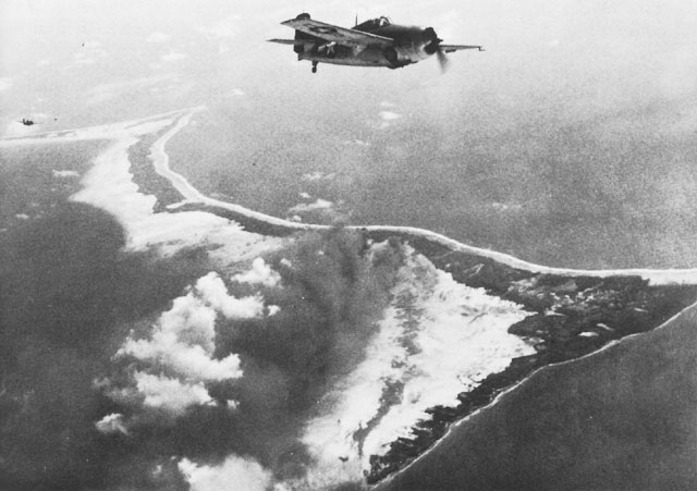
Butaritari from the Air. Navy Wildcat fighters over the island on 20 November 1943.USMC, which had staged a raid on Makin on 16 August 1942.34
Final Intelligence Estimates: Makin
On the basis of these various sources of information, V Amphibious Corps and the two division headquarters committed to the Gilberts were able to draw up reasonably complete and on the whole not too inaccurate estimates of the geographical nature and defensive strength of the target islands.
Makin is an atoll located approximately 2,000 nautical miles southwest of Oahu. It is north of Tarawa by about 105 miles, southeast of Kwajalein in the Marshalls by 450 miles, and east of Truk by 1,265 miles. The atoll is triangular in shape enclosing a large lagoon. Map 3) The southeastern leg of the triangle holds the main land formation, consisting of two long islands, Butaritari and Kuma, which with their connecting reef are about thirteen miles long and average five hundred yards in width with the highest land point rising no more than twelve feet above sea level. Butaritari was rightly believed to contain the largest number of natives, the entire population of the atoll being estimated as about 1,700 at
the time of the Japanese occupation in December 1941.
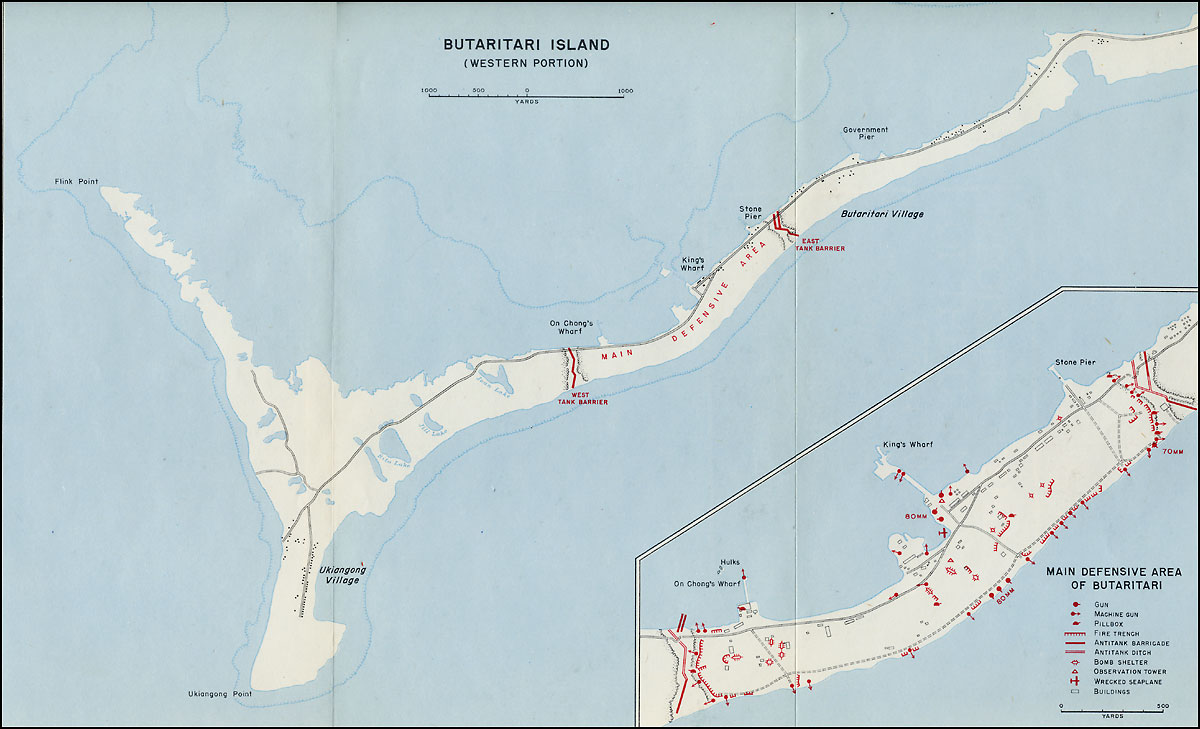
Butaritari, according to the 27th Division's G-2 terrain study, was "shaped like a crutch with the armrest facing generally West and the leg of the crutch pointing East and slightly North."35 For purposes of tactical study the island was divided into three parts. The extreme western area, that is the armrest of the crutch, was thought to be generally of good substantial footing with scattered coconut trees and sand brush on the northern part and thick coconut groves interspersed with bobai (taro) pits in the southern. East of this area was a stretch of land designated the inland lagoon area. Except near the shore this was believed swampy, covered with saltbrush, and impassable in many parts for vehicles. Near the geographical center of the island was the main village of Butaritari situated on fairly dry ground. The easternmost segment of the island was believed to contain good land, with some bobai pits and gradually thickening coconut growth as the extreme eastern tip was approached. A road had been observed running from Ukiangong Village, near the southwest point, in a northerly direction about half way out Flink Point, a promontory on the northwest side. The road connected with another that ran in a northeasterly direction along the north shore of the island to its eastern tip. A short cross-island road ran through Butaritari Village from the northern (lagoon) to the southern (ocean) shore.
On the all-important question of suitable spots for landing, it was believed that the best beaches were those on the lagoon (north) shore and on the southern half of the west coast of the island. On the west coast the reef was thought to be very close to the beach, therefore offering no particular hazard to ordinary landing craft. On the lagoon side, the reef was estimated to extend 500 to 1,500 yards out from the shore, but was considered to be flat and even enough to permit troop landings at the reef's edge. Four prominent landmarks presented themselves on the lagoon side. These were, from west to east, On Chong's Wharf, King's Wharf, Stone Pier, and Government Wharf. All projected far enough into the lagoon to be useful as guide marks for landing craft.
No particular difficulties were contemplated by the division planners from tidal or hydrographic conditions. It was believed that single boats could land at almost any point on the island during high water and two hours before and after high water. This was an error as events were soon to prove. Had the division planners carefully consulted Admiral Turner's operation plan, they would have discovered that during periods of neap tide (and 20 November fell in such a period) standard Navy landing craft would be grounded on the reef off the lagoon shore some 100-150 yards out.36
The Japanese garrison on Butaritari was estimated to be from 500 to 800 troops consisting of one rifle company, one field battery of four heavy antiaircraft guns, and two antiaircraft machine gun batteries totaling four medium antiaircraft guns and twenty machine guns.37 It was apparent
from aerial photographs that the enemy had concentrated the major part of his defenses in the central area of the island around Butaritari Village. This fortified area was bounded on east and west by tank traps running generally in a zigzag path from lagoon to ocean shore.38
Final Intelligence Estimates: Tarawa
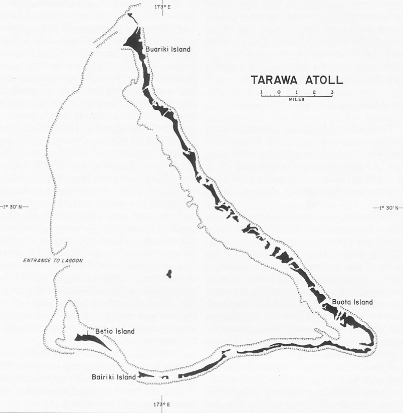
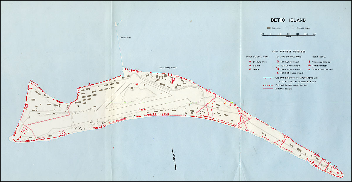
Tarawa, like Makin, is a triangular coral atoll and is roughly 18 miles long on the east side, 12 miles long on the south side, and 12.5 miles long on the west side. None of the small islands comprising the atoll rises to more than ten feet above sea level. ((Map 4)
The entire west leg of the triangle consists of a barrier reef through which there is only one entrance into the lagoon passable by deep-draft vessels. Just 3.5 miles south of this entrance lies the island of Betio, resting on the southwest corner of the triangle. It was here that the Japanese had constructed an airfield and had concentrated their major defenses. It was here that the first major amphibious assault by American forces in the Central Pacific would take place.
Betio itself is surrounded on all sides by reefs. Along the south shore the reef extends to a uniform distance of about 600 yards from the high-water line. On the narrow west shore it varies from 800 to 1,200 yards at the extreme southwest point of the island where strong rip currents occur. Off the north shore, facing the lagoon, also lies a fringing reef, but this is wider and shelves more gradually than the reefs elsewhere. This, plus the fact that the lagoon was on the lee side of the island and somewhat sheltered from heavy swells, made this coast line the most desirable for landing operations.39
Most of these facts were known to planners of the operation as a result of aerial and submarine photographs and consultation with former residents and visitors familiar with the atoll. What was not known with any certainty, however, was the condition of prevailing tides in the area. The central problem that plagued all planners of the Tarawa operation was the question of the probable height of water over the fringing reef off the north coast of Betio. The 2d Marine Division, which was assigned to the operation, had available only a limited number (eventually 125) of amphibian tractors. These vehicles, which could carry about twenty troops each, were equipped to operate both through water and overland, and to them reefs offered no particular obstacle. However, there were not enough on hand to transport all of the necessary assault troops from ship to shore. The remainder would have to be carried in standard "Higgins boats" (LCVP's) which, when fully loaded, drew at least 3.5 feet. Thus about four feet of water above the reef was essential if the landing craft were to carry the assault troops from ship to shore without interruption.
To complicate matters further the date chosen for the invasion was in a period of neap tide at Tarawa. Neap tides occur during the first and third quarters of the moon. During these times the range of tide, that is the difference between high and low water, is at its lowest point and high tides are lower than usual. Thus, the probability of there being sufficient water over the reef even at high tide on the particular
Map 4:
Tarawa Atolldate chosen for the invasion was decreased.40
These problems were all appreciated by planners on both corps and divisional levels, but their sources of information were contradictory. Admiral Turner's intelligence staff, as for Makin, made a correct estimate of tidal conditions at Tarawa on the proposed day of landing. His operation plan reads in part: "During high water neap tides the reef [that is, the lagoon reef]
off the north coast of Betio is covered by from one to two feet of water . . . ."41 If this analysis were to be believed, then it was obvious that nothing but amphibian tractors could negotiate the reef on 20 November, which was known to fall in the period of neap tide. Standard landing craft drawing from three to four feet would be grounded on the reef. Admiral Turner's staff also knew that during neap tides a "dodging" tide frequently occurred at Tarawa, that is, the tide instead of following the usual semi-diurnal pattern, ebbed and flowed several times in twenty-four hours.42 This might further complicate the problem of getting standard landing craft ashore, even through channels blown in the reef.
Either this information was improperly understood or it was disbelieved, because up to the very date of the landing there was still hope that at Betio there would be enough water over the reef to float standard landing craft. This hope was nurtured by several former residents of the Gilberts and shipmasters who had navigated the adjacent waters. All but one of these consulted by the staff of the 2d Marine Division affirmed that five feet of water could be expected over the reef at Betio at high tide. The single exception was Maj. F.L.G. Holland, a British officer who had lived on Bairiki, the island adjacent to Betio, for fifteen years. During the Marine division's final rehearsals on Efate in the New Hebrides before sailing for the target island, Major Holland announced that during neap tide periods less than three feet of water could be expected at high tide.43
Major Holland was right and in general his pessimism was shared by General Julian Smith, the 2d Marine Division's commander. At least his troops were briefed to expect no more than a fifty-fifty chance of getting into the shore on Betio in boats.44 As events turned out even this was far too optimistic an estimate.
Although hydrographic information for Tarawa was faulty, the prelanding intelligence of Japanese troop strength and defense dispositions was excellent. This was largely derived from aerial and submarine photographs assembled by the Joint Intelligence Center, Pacific Ocean Areas, and interpreted by that headquarters and by the intelligence section of the 2d Marine Division. As of 11 November, the division estimated enemy troop strength on Betio alone to be not less than 2,500 and not more than 3,100,45 a prediction that post-battle studies proved to be remarkably accurate. Betio was known to be far more heavily fortified than Makin. From aerial photographs it appeared that the north shore was defended by an elaborate system of fire trenches, rifle pits, coastal and antiaircraft weapons, antiboat emplacements, and machine gun positions. Defenses on the west and south shores were thought to be similar in all respects, including density.
On this tiny, narrow island only three miles long and less than six hundred yards across at its widest point, the Japanese were believed to have 8 or 9 coastal defense guns, 12 heavy antiaircraft guns ranging from 75-mm. to 12-cm., 12 medium antiaircraft guns from 40-mm. to less than 75-mm., 81 antiboat positions for weapons
Task Organization of Various Commands for the Attack on the Gilbert Islandsof sizes ranging from heavy machine guns to 40-mm. guns, and 52 light weapons.46 There was good reason to believe that this would be the fiercest amphibious battle yet fought in the Pacific.
Organization and Command of the American Forces
Admiral Spruance's Operation Plan Number Cen 1-43 was issued on 25 October and, subject to some subsequent modifications, set forth the command organization of the GALVANIC operation and outlined the tasks assigned to each subordinate command. The immediate task of capturing and occupying Makin, Tarawa, and Apamama, of destroying inferior enemy surface forces attempting to interfere with the landing operations, and of initiating the establishment of advance bases and the construction of airfields on the three islands was assigned to Admiral Turner's assault force (Task Force 54). This was in turn subdivided into a Northern Attack Force (Task Force 52), also commanded by Admiral Turner, and a Southern Attack Force (Task Force 53) under Rear Adm. Harry W. Hill, USN, plus sundry other lesser task groups including a reconnaissance group for Apamama, and
garrison groups for the three islands. The duty of the Northern Attack Force was to capture Makin; that of the Southern Attack Force to take Tarawa and Apamama.
The main troop components of the Northern Attack Force were to consist of the 165th Regimental Combat Team (reinforced) of the 27th Infantry Division. This combat team plus units of the 7th Army Defense Battalion and various service units were to constitute the Northern Landing Force, under command of General Ralph Smith. The parallel command for the seizure of Tarawa was the Southern Landing Force, consisting mainly of the 2d Marine Division plus assigned units of the 2d and 8th Marine Defense Battalions, all under command of General Julian Smith. A separate task group was set up for occupying Apamama. The commanding officer of the submarine Nautilus, Comdr. Donald G. Irvine, USN, was directed to land a reconnaissance platoon of V Amphibious Corps on that presumably undefended island some time after the main landings on Tarawa and Makin.
To transport the 165th Regimental Combat Team and its supplies and equipment to Makin, Admiral Turner was able to allocate four attack transports (APA's), one attack cargo ship (AKA), one LSD, and nine LST's. To screen the transports and LST's, and to provide naval gunfire and aerial support for the landing on Makin, a total of four old battleships, four heavy cruisers, thirteen destroyers, and three escort carriers (CVE's) was provided.47 To the 2d Marine Division for the assault on Tarawa was assigned one transport (AP),48 twelve attack transports, three attack cargo ships, one LSD, and twelve LST's. To screen these vessels and to bombard the shore at Tarawa, Southern Attack Force had a total of three battleships, three heavy cruisers, three light cruisers, twenty-one destroyers, and five escort carriers.49
Thus, about equal shares of naval gunfire support were apportioned to the Makin and Tarawa landings, although it was known that the latter would be by far the more formidable target. If the only problem involved in the operation had been that of landing troops on the two islands, then logic would have dictated allocating a far heavier portion of naval gunfire support to the Southern Landing Force. As it was, purely naval considerations prompted a more equal division of fire power. Makin was more than a hundred miles closer than Tarawa to the Marshalls and if any major sortie by the elements of the Japanese fleet should develop, it would probably be from that direction. Hence, it was considered prudent to dispose a good part of the American combat vessels in a position where it could more quickly intercept a Japanese naval counterattack.50
Within Admiral Turner's assault force (Task Force 54), but not enjoying any clear-cut authority, was the Commander, V Amphibious Corps, General Holland Smith. During the planning and training phase, both the 2d Marine Division and the 27th Infantry Division were clearly attached to Holland Smith's headquarters
and were under his command.51 But for the operational phase, his position in the chain of command was ambiguous. Admiral Spruance's operation plan provided that the "Commanding General Fifth Amphibious Corps will be embarked in the flagship of the Assault Force [Task Force 54] and will command all landing force troops."52 However, by the same order, all directives by Commander, V Amphibious Corps, had to be approved by Admiral Turner as Commander, Assault Force, before they could be issued. Furthermore, the only authority specifically delegated to Holland Smith under Admiral Turner's own operation plan was that "Commanding General, Fifth Amphibious Corps, embarked in the Force Flagship of the Commander Assault Force, will advise the Commander Assault Force in regard to the employment of the Landing Forces at each objective and the employment of reserve troops . . . ."53
On the question of the immediate command of troops to be committed ashore at Makin and Tarawa, both Spruance's and Turner's orders bypassed Holland Smith. At both objectives the related attack force commanders--Turner, Commander, Task Force 52, at Makin, and Hill, Commander, Task Force 53, at Tarawa--were to command the troops through the appropriate landing force commanders (that is, General Ralph Smith, USA, at Makin and General Julian Smith, USMC, at Tarawa). These last two officers would assume command ashore only when Admiral Turner, as commander of the assault force, should so direct.54
In other words, General Holland Smith was given no tactical command over troops.55 His capacity during the operation was merely that of an adviser to Admiral Turner. However, there is evidence that in his own mind General Smith believed that he held a more exalted position. Later, he wrote, "As soon as the assault waves hit the beach the status of my command was parallel, not inferior to, Kelly Turner's."56 This misconception could easily have arisen from the paragraph of Admiral Spruance's operation plan cited above, which seemed to give the V Amphibious Corps commander command over "all landing force troops." The confusion was further compounded when at the last minute Admiral Nimitz issued a directive removing General Holland Smith's name from the command. Smith protested and at last, in his own words, "Admiral Spruance insisted that I go along."57 Go he did, but as an adviser, not a troop commander.
Comparable to, but not exactly analogous with, the position of General Smith in the chain of command was that of the Commander, Support Aircraft, Col. William O. Eareckson, AAF. At this juncture in the Pacific war, the Navy's development of a centralized system of ground control of support aircraft in amphibious operations was still in a formative stage. At Guadalcanal Admiral Turner had set up a rather hasty, temporary control organization for aircraft assigned to troop support. Under his plan, during the amphibious phase of the operation, all troop support aircraft were controlled by an air support director group attached to his staff
and aboard his flagship, the USS McCawley, with a similar stand-by group aboard the USS Neville, which was assigned to waters off Tulagi. In addition, a fighter squadron, flown from carriers located far out at sea and assigned the duties of combat air patrol in the immediate area of the landing, was controlled by Rear Adm. Victor A.C. Crutchley, R.N., Turner's second in command, through a fighter director group located aboard the USS Chicago.58
Although this plan did not permit completely centralized control, it did embody two important principles. First, all aircraft in the objective area were under command of units on board ships actually present. Secondly, after the initially scheduled strikes, all missions for troop support aircraft were established by the air support director group aboard the force flagship as a result of requests from the commanders of the landing forces, that is, of the troops ashore.
After his appointment to the post of Commander, Fifth Amphibious Force, Central Pacific, Admiral Turner sought to capitalize on his experience at Guadalcanal by setting up an air support control organization on a permanent basis. But he found little enthusiasm for the project among naval air circles at Pearl Harbor and no naval aviator who, in his opinion, had sufficient rank or experience to do the job. However, in the person of Colonel Eareckson, then temporarily attached to Admiral Nimitz's headquarters, he discovered an aviator who met his requirements. Colonel Eareckson had acted as an air co-ordinator and air-ground liaison officer for close support missions flown by planes of the Eleventh Air Force during the invasion of Attu in May 1943.59 Although he had not previously worked with naval aircraft, he was borrowed from Admiral Nimitz's staff for the Gilberts operation and designated Commander, Support Aircraft.
The scope of his duties and authority for the forthcoming invasion was not made entirely clear in the covering operation plans, the ambiguity being a reflection of a yet unmatured conception of the role of close air support control in naval amphibious doctrine. According to Operation Plan A2-43, issued by Admiral Turner as commander of the assault force for the entire Gilberts operation (Task Force 54), "The Commander Support Aircraft, GALVANIC [Eareckson], embarked in the Force Flagship of the Commander Assault Force [Turner], will advise the Commander Assault Force in regard to the employment of support aircraft at all objectives."60 In another paragraph of the same plan it is stated, "At each objective, during the assault, the related Attack Force Commanders [that is, Turner at Makin, and Hill at Tarawa] will command the support aircraft through the Air Commander of the base to be established at the objective . . . ."61
This would seem to indicate that Colonel Eareckson's position in the chain of command was, like General Holland Smith's, merely that of adviser to the assault force commander, Admiral Turner. Also, according to the above cited plan, the attack force commander at each objective would presumably exercise direct command over support aircraft through the air base commander ashore, once such bases were established. However, in practice,
this was not to be the case. Since this command setup had been ordained by directives from higher authority, it could not be changed. But Admiral Turner did succeed in radically modifying the arrangement by directing that at both Tarawa and Makin flight leaders of combat air patrols, upon being relieved from this type of duty, should report to the Commander, Support Aircraft, and be prepared to strafe ground installations as directed by him before returning to their carriers. To insure safety to the ground troops, pilots were warned that it was "imperative that strafing attacks be delivered only as directed by the Support Aircraft Commander."62 Also, supporting aircraft at both Makin and Tarawa were ordered to maintain twelve scout bomber planes and six torpedo bomber planes on each station during daylight at an "initial point" designated by the support aircraft commander to give direct support to ground troops and to replace the Support Aircraft Group as requested by the support aircraft commander. In addition, antisubmarine patrol aircraft were ordered to report to the support aircraft commander upon arrival on and departure from station.63
As it finally went into effect, then, the duties of the support aircraft commander both at Makin and at Tarawa were made more positive than had originally been contemplated. Colonel Eareckson, who would sail aboard Turner's flagship, was given general direction over close air support and antisubmarine patrol for the whole assault force (Task Force 54). In addition, he had direct command duties with respect to support aircraft of the attack force at Makin (Task Force 52). For the Tarawa phase, a second commander of support aircraft was assigned to Task Force 53 and accompanied Admiral Hill on his flagship Maryland, from which he too would directly command close air support and antisubmarine patrol at that objective.64 In later amphibious landings in the Central Pacific this allocation of air responsibilities was formalized and clarified, but it was in the Gilberts operation, in spite of some confusion in the covering plans, that this subsequent development was clearly forecast.
Aerial support, both tactical and strategic, was to be provided in the main by two separate task forces. The carrier force (Task Force 50) was under command of Rear Adm. Charles A. Pownall, USN, and consisted of six large and five small carriers with their accompanying battleships, cruisers, and destroyers. The bulk of this force was assigned the task of destroying enemy aircraft and defenses on Tarawa on D minus 2 and D minus 1 and on Mille, Jaluit, and Makin on D minus 1. At the same time, planes from this force were to photograph both Makin and Tarawa and deliver copies, together with information of sea conditions at landing beaches, to Admirals Turner and Hill on their respective flagships. On D Day and daily thereafter they were to conduct early morning searches to the north and west of the Gilberts and to provide air support for the land operations. One relief group of this task force was ordered to destroy aircraft and air harbor facilities on Nauru by both air and surface bombardment.65
All shore-based aircraft for the operation were organized into Task Force 57 under the command of Rear Adm. John H. Hoover. The Seventh Air Force provided Admiral Hoover with both fighters and bombers. Ninety heavy bombers were
organized into Task Group 57.2, commanded by Maj. Gen. Willis H. Hale, AAF. Fifty-six Navy patrol bombers were placed in Task Group 57.3 under direct command of Admiral Hoover. A third task group (57.4) consisted of ninety Marine fighter planes, seventy-two Marine scout bombers, twenty-four scout and utility planes, and sundry Army and Navy transport planes--all to be based on the Ellice Islands and all under command of Brig. Gen. Lewie G. Merritt, USMC.
Task Force 57 was to attack enemy air bases at Tarawa, Nauru, Mille, Jaluit, and such other enemy positions in the Marshalls as were within range. The force was to conduct photographic reconnaissances of Kwajalein, Wotje, Maloelap, Mille, and Jaluit, all in the Marshalls. Starting on D minus 3, it was to conduct long-range searches in areas not covered by carrier planes. Other general duties were to attack enemy ships and shipping, defend American bases in the Ellice and Gilbert Islands, and provide air transportation.66
All of this air power was in addition to the planes attached to the two attack forces. At Makin, three escort carriers would accompany Admiral Turner's Northern Attack Force. Admiral Hill's Southern Attack Force at Tarawa would enjoy the support of five such vessels.67
Admiral Turner's Plan for the Attack
The general plan for the operation, as worked out by Admiral Turner in conjunction with the staff of V Amphibious Corps, contemplated the simultaneous capture of Makin by the 165th Regimental Combat Team of the 27th Infantry Division and of Tarawa by the 2d Marine Division, reinforced. One regimental combat team of the Marine division (later designated the 6th RCT) was to be held as corps reserve for the support of one or both of these operations or for the subsequent occupation of Apamama. This corps reserve was to be employed only as authorized by Admiral Turner as Commander, Task Force 54, on the advice of General Holland Smith.68
The assault was to be made initially by troops carried in amphibian tractors, some fitted with grapnels for destroying wire and thus opening boat routes to the beaches. The tractors would be carried to the target areas in LST's, each of which had space in its tank deck for seventeen vehicles. The amphibian tractors would be followed by troops in LCVP's (landing craft, vehicle and personnel) and by medium tanks transported in LCM's (landing craft, mechanized), which would be carried forward by Navy transports and by LSD's.
On D Day at both Makin and Tarawa Navy planes were to strike from 0545 to 0615, attacking coast defense guns, heavy antiaircraft guns, observation towers, radio installations, aircraft, and personnel, as well as any barracks and buildings undamaged by previous attacks. From about H Hour minus 5 minutes to H Hour plus 15 minutes (that is from 5 minutes before to 15 minutes after the first troops hit the beach), planes would attack installations on the landing beaches. They were to strafe along the water's edge until the first wave of landing craft approached to within 100 yards of the beach, then shift fire inland to a depth of 100 yards. Immediately thereafter, they were to bomb all secondary defense installations behind the beaches clear across each island as well as all beach installations between 500 and 1,000 yards to both sides of the landing
areas. Following these scheduled missions, aircraft were to fly combat air patrol and antisubmarine patrol and carry out bombing and strafing attacks in close support of the ground troops.69
For Makin, naval gunfire support would be provided by four old battleships, four cruisers, and six destroyers.70 For Tarawa, three battleships, two heavy cruisers, three light cruisers, and nine destroyers would be assigned to this duty.71 The general plan for the employment of these vessels at both objectives was as follows: During the early morning of D Day, commencing about 0615, the heavy ships would deliver prearranged neutralization and counterbattery fires at moderately long range. As mine sweepers gradually closed the beaches off Makin and swept the lagoon off Betio, support vessels would move to closer range. Battleships and heavy cruisers were permitted to move in as close as 2,000 or 3,000 yards (that is, one to one and a half nautical miles) in order to knock out heavy turret guns ashore. Shortly before the landing, light cruisers and destroyers were instructed to move to still closer range for a last-minute saturation fire. This was to terminate at H minus 5 minutes so as to permit a final air strike on the beaches immediately before the first wave of troops hit. Under no circumstances were ships and planes to bombard the same areas simultaneously. After the landings had been made ships were to stand by to fire on targets of opportunity on request of shore fire control parties attached to troop units and to deliver slow neutralization fire on areas 400 to 800 yards or more from the nearest troops.72
It was believed by some naval planners of the operation that this tremendous volume of preliminary naval gunfire coupled with the proposed aerial bombardment would surely be ample to knock out most of the heavier Japanese installations and at the very least neutralize the beaches during the assault phase of the operation. Just before the 2d Marine Division sailed from Efate, one of the ranking naval officers is reported to have stated of Betio: "We do not intend to neutralize it, we do not intend to destroy it. Gentlemen, we will obliterate it."73 Such optimism was extravagant, as the course of the battle would show, but it was based on the knowledge that in no previous amphibious operation had such a tremendous weight of naval and air power been available to landing troops. That a mere two and a half hours of preliminary naval bombardment, no matter how concentrated, was still not enough to "obliterate" even tiny islands the size of Betio and Butaritari was still to be proved.
The 27th Division's Plan: Butaritari
For the landing on Butaritari, total troop strength of the 165th Regimental Combat Team with its attached units came to 6,470 men. This included, besides the infantry troops of the 165th, detachments from the 105th Infantry Regiment of the 27th Division, part of the 193d Tank Battalion, the 152d Engineer Battalion, coastal artillery and antiaircraft batteries of the 98th and 93d Coastal Artillery Battalions, a platoon from the V Amphibious Corps Reconnaissance Company, plus sundry
medical, signal, ordnance, quartermaster, and bomb disposal detachments.
The plan for getting these troops ashore on Butaritari was elaborate in the extreme and unlike any adopted before or since in the Pacific war. It was devised by General Ralph Smith, Commanding General, 27th Division, and approved somewhat reluctantly by General Holland Smith, commander of the V Amphibious Corps.74 The basic principle of the plan was to land two battalions on the west coast of Butaritari, followed quickly by tanks and artillery pieces. Two hours after the main landing, a third battalion was to be put ashore on the north (lagoon) side of the island roughly 4,000 yards east of the main landing beaches. This battalion would then split into two groups, one heading eastward, the other westward in the general direction of the main landing force. The object was to envelop in an amphibious pincers movement the Western Tank Barrier that lay athwart the island between the main landing beaches on the west coast and the most heavily fortified area in the center--the so-called Citadel area.
Map II: Butaritari IslandThe first wave to land on the west coast (at Red Beaches) was to consist of thirty-two LVT's embarked on two LST's, manned by separate detachments of the 105th Infantry (called Detachments X and Y). These were to land at Red Beaches at H Hour and to clear a passage through any barbed wire or other underwater obstacles that might impede the succeeding landing craft. On hitting the shore, the troops were to move south and north respectively and cover the right and left flanks of the main landing beaches.75
This scheme of manning the first wave of LVT's with troops drawn from a regiment outside of the one that made up the main landing force was a product of necessity rather than choice. Because of the prevailing shortage of LVT's at the time of the operation, General Ralph Smith could not be certain that any of these vehicles would be available for the Makin landing. Not until about two weeks before sailing from Pearl Harbor did the tractors assigned to the 27th Division actually arrive. Hence, in working out a landing plan, General Smith had to take into account the possibility that no amphibian tractors might be ready for the operation, and therefore assigned all of the assault troops of the 165th Regimental Combat Team to LCVP's. Against the contingency that the desired tractors would show up at the last minute, he detached special units from the 105th Regimental Combat Team of his division to make up the first wave and to perform whatever duties thereafter that might be considered desirable.76
Following this first wave of LVT's would come the assault troops of the 1st and 3d Battalion Landing Teams, 165th Regiment, boated in LCVP's. On the right, the 3d Battalion Landing Team would land on Red Beach 2 and seize the right half of the division beachhead to about 1,600 yards inland. It would then move right to clear the area around Ukiangong Village and Ukiangong Point. On the left, the 1st Battalion Landing Team would land on Red Beach 1, seize the division beachhead in its zone of action and move left to capture the area from the north end of Red Beach to Flink Point. Upon capture of the division beachhead, it was to relieve the right battalion on the entire front line and
push reconnaissance as far east as "Jill" Lake. Upon being relieved, the 3d Battalion would assemble in dispersed formation as division reserve in the area north of Ukiangong Village.
Two hours later, at W Hour (1030), the second landings were to be made on Yellow Beach 2 on the north shore between On Chong's Wharf and King's Wharf, both of which projected out into the lagoon. Here, too, the first wave would consist of sixteen LVT's mounted aboard an LST and would be manned by Detachment Z of the 105th Infantry Regiment. On arrival at the beach the troops were to dismount, half of them moving directly east to clear the enemy from King's Wharf and establish a beach block and defensive position on the left flank of the beach. The other half was to move directly west, clearing any Japanese found on On Chong's Wharf and protecting the right flank of the beach. Following this wave would come the assault troops of the 2d Battalion Landing Team, 165th, with Company A of the 193d Tank Battalion attached and boated in LCVP's and LCM's. Upon seizing the beachhead, this battalion was to make its main effort to the westward to effect contact with the 1st Battalion Landing Team, which at that juncture was supposed to be moving eastward from the main division beachhead.
Meanwhile, at H Hour the platoon of the V Amphibious Corps Reconnaissance Company with one reinforced infantry platoon from the 2d Battalion, 165th Infantry, was to have landed on tiny Kotabu Island just north of Flink Point so as to secure the seaward approaches into the lagoon from possible enemy fire from that quarter. As soon after H Hour as was permissible, the three artillery batteries of the 165th Regiment were to be landed over Red Beach 2 and take position on Ukiangong Point. Two of these batteries consisted of the standard 105-mm. howitzers organic to regiment. Because of limitations in shipping space, 75-mm. pack howitzers had to be substituted for the third battery.77
The basic premise upon which this plan was made was that the first main obstacle to a quick capture of the island would be the West Tank Barrier. This consisted of a trench about six feet deep and over fourteen feet wide and extended by log fences. The whole system was laid out in a north-south direction across the island about 3,400 yards east from Red Beaches.78 It was believed that this barrier would seriously impede the progress of tank-infantry teams approaching from the west coast, and that the best method of eliminating the hazard was to envelop it. Since this would necessitate two battalions moving toward each other, each was instructed to use special colored smoke grenades and to maintain close radio contact. By these safeguards it was hoped that the danger of a fire fight between the American units would be minimized.79
What this plan failed to take into account was the potentiality of naval gunfire. The tank barrier offered an ideal target for enfilade fire by destroyers lying off either the lagoon or the ocean side of the island. However, as of the autumn of 1943, the efficacy of naval gunfire against shore targets had not yet been proved to the satisfaction of 27th Division planners. General Ralph Smith and his staff were still skeptical of this particular type of fire,80 hence they felt compelled to rely almost entirely on their tank-infantry teams to overcome
the western tank barrier and establish a foothold on Butaritari.
Another defect in the plan was that it relied too heavily on the assumption that communications between separate units would be adequate. To avoid the danger of a fire fight between the two infantry forces as they approached each other, it was essential that they be in perfect communication with each other. Also, if artillery was to be used at all in the gap between the two forces, it would be imperative that close radio or telephone contact be maintained between the artillery battalion and the various infantry commanders. As it turned out, no such contact was established during the first day's fighting on Makin.
2d Marine Division's Plan: Betio
By contrast, the plan for landing the 2d Marine Division on Betio was a model of simplicity. General Julian Smith had under his control only two reinforced regiments of his division, the 2d and 8th Regimental Combat Teams. The 6th Regimental Combat Team was to be held in corps reserve to be landed at Tarawa, Makin, or Apamama as the situation dictated. General Smith's plan called for the landing of three battalion landing teams abreast on Red Beaches 1, 2, and 3 on the north (lagoon) shore of Betio.
The first three assault waves were to be made up of amphibian tractors, the fourth wave would be tanks boated in LCM's, the fifth would be LCVP's, each carrying about thirty-six troops.81
Map III: Betio IslandThe first troops to land would be, from east to west (left to right) the 2d Battalion, 8th Marines; 2d Battalion, 2d Marines; and 3d Battalion, 2d Marines. The 1st Battalion, 2d Marines, was to be held in regimental reserve. In division reserve, to be committed when and where the situation warranted, would be the 1st and 3d Battalions of the 8th Marines.
As soon as the beachhead was secured, the assault troops were to move directly across the island to the south, seizing the airfield and mopping up enemy positions along the ocean beaches. When this task had been completed, the two battalions on the east were to pivot and move to the left along the axis of the island to clean it off to its eastern tip. The artillery regiment (10th Marines) was to land on order on the main beaches and prepare to mass the bulk of its fires from Central Pier (which jutted out into the lagoon almost on the boundary between Red Beaches 2 and 3) to the eastern end of Betio.
With the withdrawal of the 6th Marines from division control, General Julian Smith could count on having only about a two-to-one superiority over the Japanese, who were reckoned to number somewhere between 2,500 and 3,100.82 This was considerably under the classic three-to-one superiority which, according to standard amphibious doctrine, is the minimum ratio desirable. If the assault was to proceed with the speed and ease hoped for, this deficiency in troop strength would have to be made up for by the preliminary naval and aerial bombardment and by the sustained momentum of the first five waves of assault troops and tanks. If any of these failed to materialize--that is, if aerial and naval bombardment proved less destructive than expected or if the ship-to-shore movement broke down--then the burden imposed on the invading troops would be unduly heavy. Events at Tarawa were soon to prove this to be the case.
Footnotes
1. R. W. Robson, The Pacific Islands Handbook, 1944 (New York: The Macmillan Company, 1946), p. 146.
2. Ibid., p. 161.
3. Memo, JPS for JWPC, 27 May 43, sub: Examination into Pacific Theater, with JWPC 39/D in ABC 384 Marshall Islands (10 Jun 43), 1.
4. JPS 205, 10 Jun 43, title: Opns Against Marshall Islands.
5. OPD brief, title: Notes on Preliminary Rpt by JWPC, Opns Against Marshall Islands, attached to JPS 205, ABC 384 Marshall Islands (10 Jun 43), 1. OPD was wrong about the amphibian tractor, which was neither new nor untried. It had given excellent service during the landings in the Solomons in August 1942.
6. Min, 80th mtg JPS, 13 Jun 43; JWPC 54/1/D, 14 Jun 43, title: Sequence of Certain Pacific Opns.
7. Min, 92d mtg JCS, 15 Jun 43; Rad, COMINCH to CINCPAC, CM-IN 9983, 16 Jun 43; Rad, JCS to MacArthur, CM-OUT 6093, 15 Jun 43.
8. MacArthur was referring here to the attempted Japanese invasion of Midway, which was supported exclusively by carrier aircraft.
9. Rads, MacArthur to Marshall, CM-IN 13149, 20 Jun 43, and CM-IN 13605, 22 Jun 43.
10. JPS 205/2, 18 Jun 43, title: Opns Against Marshall Islands.
11. OPD brief, title: Summation of Memo on Opns in CENPAC, with JPS 205/2 in ABC 384 Marshall Islands (10 Jun 43), 1; OPD brief, Notes on 94th Mtg JCS, 29 Jun 43, with JCS 386 in OPD 384 Pacific (28 Jun 43).
12. JCS 386, 28 Jun 43, title: Strategy in the Pacific.
13. Fleet Admiral William D. Leahy, I Was There (New York: Whittlesey House, 1950).
14. Min, 94th mtg JCS, 29 Jun 43.
15. JCS 386/1, 19 Jul 43, title: Strategy in the Pacific.
16. Min, 97th mtg JCS, 20 Jul 43.
17. JCS 386/2, 20 Jul 43, title: Strategy in the Pacific; Rad, JCS to CINCPAC, CM-IN 14465, 20 Jul 43.
18. Memo, CNO for CofS, 14 Jun 43, sub: Withdrawal of 1st Marine Div, and Memo, CofS for CNO, 23 Jun 43, sub: Withdrawal of 1st Marine Div and Change of Allocation of 2 Army Divs. Both in OPD 320.2 Australia 184.
19. Ltr, CNO to CofS, 22 Jul 43, OPD 381 Security 196.
20. Capt. Edmund G. Love, The 27th Infantry Division in World War II (Washington: Infantry Journal Press, 1949), p. 21; Memo, CofS for CNO, 29 Jul 43, sub: Release of 1st or 3d Marine Divs for Opns in CENPAC, OPD 381 Security 196. General Marshall does not seem to have been quite satisfied with the status of the 27th Division. See his informal memo for Maj. Gen. Thomas T. Handy in OPD 381 Security 196.
21. Memo, Vice Adm Richard S. Edwards [CofS to King] for Gen Marshall, 31 Jul 43, sub: Designation 27th Div to Gilbert Opn, OPD 381 Security 196.
22. Cmdr Fifth Amph Force, U.S. Pacific Fleet, Rpt of Amph Opns for the Capture of the Gilbert Islands, 4 Dec 43 (hereafter cited as Fifth Amph Force Rpt, Capture of Gilbert Islands), p. 1.
23. History of United States Army Forces Middle Pacific and Predecessor Commands During World War II, 7 December 1941-2 September 1945 (hereafter cited as USAFMIDPAC Hist) p. 100, MS in OCMH.
24. Capt. James R. Stockman, USMC, The Battle for Tarawa (Washington, 1947). The present approved (Board of Geographic Names) spelling is "Abemama." As of 1943-44, however "Apamama" was in accepted usage and it was this spelling that was uniformily employed in American military plans and reports. Therefore, the spelling "Apamama" will be used in this volume.
25. Participation of the United States Army Forces in the Central Pacific Area in GALVANIC Operation (hereafter cited as USAFICPA Participation Rpt GALVANIC), pp. 131-37; 27th Inf Div Rpt of G-2 Activities, GALVANIC Opn.
26. Ltr, Cmdr Fifth Amph Force to COMCENPAC, 94 Sep 43, sub: GALVANIC Opn, Discussion of Substitution of Makin as Assault Objective Instead of Nauru, Ser 0037, File 1975 Operation and Training (GALVANIC) Folder I, VAC files, Naval Records Management Center, Mechanicsburg, Penna.
27. V Phib Corps GALVANIC Rpt, 11 Jan 44, p. 2.
28. CINCPAC-CINCPOA Opns Plan 13-43, 5 Oct 43.
29. Fifth Amph Force Rpt, Capture of Gilbert Islands. Annex A, p. 5. Both of these target dates were arbitrarily fixed as west longitude dates, although the Gilberts lie in east longitude about seven degrees west of the international date line. During this operation then, the target islands were presumed to be in plus-twelve time zone, although actually lying west of it. In effect this meant that all local date-time groups during the operation were computed as Greenwich civil time minus twelve hours.
30. Fifth Amph Force Rpt, Capture of Gilbert Islands, Incl C, p. 2.
31. V Phib Corps GALVANIC Rpt, Incl C, p. 2.
32. Fifth Amph Force Rpt, Capture of Gilbert Islands. Incl C, p. 2.
34. 27th Inf Div Rpt of G-2 Activities, GALVANIC Opn, p. 6; Ltr, Maj Gen Ralph Smith, USA (Ret), to Chief, HD SSUSA, 31 Jan 49, Incl, p. 2, OCMH.
35. 27th Inf Div FO 21, 23 Oct 43, App 1 to Annex p. 1. The account given here of intelligence estimates of Makin is derived from this appendix and the situation map of Butaritari Island, Makin Atoll, prepared by G-2, V Phib Corps.
36. TF 54 Opn Plan A2-43, 23 Oct 43, Annex B, p. 21.
37. 27th Inf Div FO 21, Annex 2, p. 1: V Phib Corps GALVANIC Rpt, Incl C, p. 3. The estimate given in the situation map prepared by G-2, V Phib Corps, differed as follows: heavy AA guns, 3 definite; medium AA guns, 1 definite, 10 possible; machine guns, 24 definite, 89 possible.
38. V Phib Corps G-2 Situation Map, Butaritari Island.
39. 2d Marine Div, Special Action Rpt, 6 Jan 44, Incl A, Narrative Account of the Gilbert Islands Opn, p. 3.
40. For a more complete discussion of the question of tides at Tarawa, see Jeter A. Isely and Philip A. Crowl, The U.S. Marines and Amphibious War (Princeton, New Jersey: Princeton University Press, 1951), Ch. VI.
41. TF 54 Opn Plan A2-43, 23 Oct 43. Annex B, p. 11.
42. Ibid., p. 29.
43. Stockman, Tarawa, p. 4; Interv, Jeter A. Isely with Lt Gen Julian C. Smith, USMC (Ret), 28 Oct 48, on file, Princeton University Library, Princeton,
44. Interv cited n. 43; Memo, Lt Col William C. Chamberlin, USMC, for Jeter A. Isley, 29 May 50, on file, Princeton University Library, Princeton, N.J.
45. 2d Marine Div Opn Order 14, 25 Oct 43, Addendum 1 to App 1 to Annex D, 11 Nov 43.
46. 2d Marine Div Opn Order 14, 25 Oct 43, App 1 to Annex D; Ibid., Addendum 1, 11 Nov 43.
47. TF 52 Amph Attack Order A3-43, 23 Oct 43; Fifth Amph Force Rpt, Capture of Gilbert Islands, p. 5.
48. The main differences between the AP and APA were that the latter carried more landing craft and was better constructed and rigged to unload assault troops and their supplies rapidly.
49. Fifth Amph Force Rpt, Capture of Gilbert Islands, p. 5; TF 53 Opn Order A104-43 (Revised), 4 Nov 43, pp. 1-2.
50. COMCENPACFOR, Gen Instr to all Flag Officers, CENPACFOR, for Gilberts Opn, 29 Oct 43, Naval History Division.
51. Stockman, Tarawa, p. 3; USAFMIDPAC Hist, Vol 1, pp. 108-09.
52. COMCENPACFOR Opn Plan Cen 1-43, p. 11.
53. TF 54 Opn Plan A2-43, 23 Oct 43, p. 9.
54. COMCENPACFOR Opn Plan Cen 1-43, p. 12; TF 54 Opn Plan A2-43, 23 Oct 43, p. 10.
55. Ltr, Adm Turner to Maj Gen Harry J. Malony, USA, Chief. HD SSUSA, 17 Jan 49, OCMH.
56. Holland M. Smith, Coral and Brass (New York: Charles Scribner's Sons, 1949), p. 113.
57. Ibid., p. 117.
58. Ltr. Adm Turner to Gen Ward, 30 Oct 50, pp.1-2, OCMH; Miller, Guadacanal, pp. 37-39.
59. Craven and Cate, AAF IV, pp. 382-86.
60. TF 54 Opn Plan A2-43, 23 Oct 43, par. 5(d).
61. Ibid., par. 5(f).
62. TF 54 0pn Plan A2-43, 23 Oct 43, Annex C, pp. 4, 10.
63. Ibid., pp. 4, 10, 11.
64. Ltr, Turner to Ward, 30 Oct 50, pp. 4-6.
65. CENPACFOR Opn Plan Cen 1-43, pp. 4-5, 8-9.
66. Ibid., pp. 5-6, 12-13.
67. See above, pp. 00-00.
68. TF 54 Opn Plan A2-43, 23 Oct 43, Annex A.
69. Ibid., Annex C, pp. 2-4, 8-9.
70. TF 52 Amph Attack Order A3-43, 23 Oct 43, p.1.
71. TF 53 Opn Order A104-43 (Revised), 4 Nov 43, pp. 1-2.
72. TF 54 Opn Plan A2-43, 23 Oct 43, p. 5: Ibid., Annex C, pp. 2-3, 8-9.
73. Earl J. Wilson, Jim F. Lucas, Samuel Shaffer, and C. Peter Zurlinden, Betio Beachhead (New York: Tim Putnam Company, 1945), p. 32.; Interv, Isely with Julian Smith, 28 Oct 48, p. 4.
74. General Ralph Smith's personal diary, which he kindly loaned to the authors, gives evidence of an original disagreement between himself and General Holland Smith on the landing plan. Holland Smith at first favored a head-on assault from the lagoon, instead of landing two battalions on the west coast and a third, later, on the lagoon shore. (Entry, 9 Oct 43).
75. 27th Inf Div FO 21, 23 Oct 43.
76. Interv, Philip A. Crowl with Maj Gen Ralph C. Smith, USA (Ret), 30 Oct 50, OCMH.
77. Ltr, cited n. 34.
78. V Phib Corps G-2 Situation Map, Butaritari Island.
79. Ltr cited n. 34.
80. Interv cited n. 76.
81. 2d Marine Div Opn Order 14, 25 Oct 43, with annexes.
Last updated: September 19, 2003
Transcribed and formatted by Jerry Holden for the HyperWar Foundation